
Surface elevation 356 m Length 8 km | Primary inflows Max. length 5 miles (8.0 km) Area 6.827 km² Width 1.6 km | |
 | ||
Similar Mount Pisgah, Burke Mountain, Burke Mountain Ski Area, Crystal Lake, Willoughby State Forest | ||
Lake willoughby vermont south end cove clothing optional beach
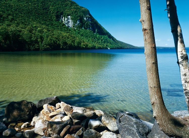
Lake Willoughby is a lake in the town of Westmore in Orleans County in the northeast section of Vermont, United States.
Contents
- Lake willoughby vermont south end cove clothing optional beach
- Map of Lake Willoughby Westmore VT USA
- HydrologyEdit
- Willoughby RiverEdit
- GeologyEdit
- Natural historyEdit
- HistoryEdit
- ToponymyEdit
- Local customs and cultureEdit
- EconomyEdit
- References
Map of Lake Willoughby, Westmore, VT, USA
The lake's southern end is surrounded by the Willoughby State Forest. This state forest includes Mount Pisgah, Mount Hor, and Bartlett Mountain (Vermont).
In 2010, Yankee magazine named Willoughby as the third best lake in New England.
Willoughby Lake is known for its beautiful public beach that stretches 0.4 kilometres (0.25 mi) on the north shore of the lake, or in the zone of the lake outlet. Another public beach is located at the bottom of the South Bay of the Lake. The village of Westmore is located on the east side, at the confluence area of Mill Creek which drains the waters of Long Pond. Many cottages and houses are located on North-East bank of the lake.
HydrologyEdit
The lake is known for its clarity and chilly temperature. Because of its depth, the surface of the lake freezes later than other lakes in the Northeast Kingdom.
Willoughby RiverEdit
Willoughby River is the outlet from the lake and runs north through Brownington to feed into the Barton River. Prior to the floods of 1927, the river had three dams. All were destroyed by the flood. An iron bridge that ran from Evansville to Brownington Center was destroyed and rebuilt.
A dam where the Whetstone Dam had formerly stood, was rebuilt to run a sawmill, which was still in operation in 2008. The "state Fish and Game Department" bought the dam rights to allow rainbow trout to swim upriver.
GeologyEdit
Lake Willoughby is a southeast trending basin. It was created by glacial action and is over 300 feet (91 m) deep in places, making it the deepest lake entirely contained in the state. Willoughby is a glacial lake over 320 feet (98 m) deep in places, the deepest lake entirely contained in the state and second to only Lake Champlain whose deepest point reaches 400 feet (120 m). Lake Willoughby resembles a Norwegian fjord.
The rock between Mount Pisgah on the east and Mount Hor on the west was eroded by a valley ice lobe. This ice flow cut across the Willoughby granodiorite and adjacent metamorphic rocks. The ice flow may have exploited highly fractured bedrock along the margin of the Willoughby pluton or joint surfaces within the pluton.
Other mountains in territory of Westmore, Vermont are on:
Natural historyEdit
Willoughby is listed as a National Natural Landmark. Willoughby contains rainbow trout (wild and stocked), Lake Trout, landlocked Atlantic salmon (mainly stocked), rainbow smelt, burbot, yellow perch, longnose sucker, white sucker, lake chub, common shiner, and round whitefish which is a native species of extremely limited distribution in Vermont. Steelhead trout (rainbow trout) are not native to the region, but were imported to Lake Memphremagog from the Pacific Northwest. They migrate up the Barton River and Willoughby River to the lake to spawn.
The sheer cliffs of Mount Pisgah and Mount Hor provide an environment conducive for arctic and cliff-alpine plants, as well as ideal nesting areas for the rare peregrine falcon.
More than 100 bird species have been recorded around the lake including thrushes, warblers, hummingbirds, jays, finches, loons, herons and gulls.
HistoryEdit
Tiny steam boats operated on the lake for tourists from 1884 to the early 1900s when steam was replaced by the gasoline engine.
In 1915, Robert Frost mentioned the lake in a poem, "A Servant to Servants,
"I see it's a fair, pretty sheet of water,
Our Willoughby! How did you hear of it?
I expect, though, everyone's heard of it.
In a book about ferns? Listen to that!"
ToponymyEdit
The toponym "lake Willoughby" was officially recognized on September 1, 1992, by GNIS (Geographic Names Information System) of United States.
Local customs and cultureEdit
Devil's Rock, located on the Mount Pisgah side of the lake at a less than halfway point from the lake's southern beach, is a popular diving spot for daring locals and vacationers. It takes its name from a painted image of a devil on the front of the rock facing out toward the lake. It is also called devils rock because when reflected in still water, the image of a skull lying on its side can be seen!
Along the eastern shore, there are a series of natural waterslides that flow into Lake Willoughby. In the winter, these turn into an ice wall which is used by ice climbers.
EconomyEdit
Lake facilities offer swimming, hiking, and ice fishing. There is a nude beach on the lake's southern shore. Surrounding the Willoughby Lake, there are some campgrounds and cottage rental services for tourists. The Route 5A runs along the lake's eastern edge.