
Max. width 1.3 km (0.81 mi) Surface elevation 418 m Length 1.6 km Mean depth 19 m | Type crater lake Max. length 1.6 km (0.99 mi) Surface area 1.4 km (0.54 sq mi) Area 140 ha Width 1.3 km | |
 | ||
Similar Lake Rotokakahi, Lake Rotorua, Mount Tarawera, Blue Lake Top 10 Holiday P, Government Gardens | ||
Lake tikitapu blue lake
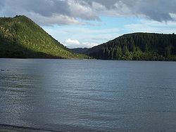
Lake Tikitapu or Blue Lake, is the smallest of four small lakes lying between Lake Rotorua and Lake Tarawera in the Bay of Plenty region of New Zealand's North Island. The others are Lake Rotokakahi (Green Lake), Lake Okareka, and Lake Okataina.
Contents
- Lake tikitapu blue lake
- Map of Lake Tikitapu Blue Lake Whakarewarewa Rotorua 3074 New Zealand
- New zealand rotorua blue lake or lake tikitapu hike
- References
Map of Lake Tikitapu (Blue Lake), Whakarewarewa, Rotorua 3074, New Zealand
Along with the others, Lake Tikitapu lies within a volcanic caldera formed within the last 300,000 years. The blue colour of the lake can be attributed to rhyolite and pumice on the lake bed. The lake has no visible outlet; however, subsurface flow drains towards Lake Tarawera.
In summer, the lake is used for recreational purposes, with many sports events being held such as water skiing and triathlons. Like many of the lakes in the Rotorua district, it is also used for trout fishing.
New zealand rotorua blue lake or lake tikitapu hike
References
Lake Tikitapu Wikipedia(Text) CC BY-SA