
Primary inflows Cities Rotoroa, New Zealand | Primary outflows Gowan River Max. depth 145 m (476 ft) Outflow location Gowan River | |
 | ||
Similar Nelson Lakes National, Lake Rotoiti, Mount Robert, Kahurangi National Park, Saint Arnaud Range | ||
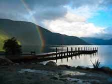
Lake Rotoroa lies within the borders of Nelson Lakes National Park in the South Island, New Zealand. The lake is fed by the D'Urville and Sabine rivers.
Map of Lake Rotoroa, Tasman District 7072, New Zealand
The greatest depth is 145 metres and the lake is completely surrounded by beech forest. Rotoroa is a small community at the base of the lake. The Gowan River flows out of the lake at this point, thus making the lake one of the sources of the Buller River system.
A track follows the northeast side of the lake and a water taxi travels the length of the lake to ferry trampers to and from the tracks at the head of the lake.
The lake has introduced trout, which attract recreational fishermen. There is a fly-fishing lodge, Lake Rotoroa Lodge, on the lake.
The word rotoroa is Māori for long lake.
References
Lake Rotoroa (Tasman) Wikipedia(Text) CC BY-SA