
Primary outflows Kymi River Max. length 120 km (75 mi) Max. depth 95.3 m (313 ft) Surface elevation 78 m Length 120 km | Average depth 16.2–18 m (53–59 ft) Area 1,080 km² Volume 18 km³ Outflow location Kymi | |
 | ||
Surface area 1,070–1,082.89 km (413.13–418.11 sq mi) | ||
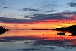
Lake freediving in finland summer 2016 lake p ij nne
Lake Päijänne ([ˈpæi(j)ænːe]) is the second largest lake in Finland (1,080 km2 (266,874 acres)). The lake drains into the Gulf of Finland via the Kymi River. The major islands are from north to south Vuoritsalo, Muuratsalo, Onkisalo, Judinsalo, Edessalo, Taivassalo, Haukkasalo, Vehkasalo, Mustassalo, Virmailansaari and Salonsaari. The largest island is Virmailansaari. The word saari means an island. Salo once meant a great island, nowadays it means a great forest area.
Contents
- Lake freediving in finland summer 2016 lake p ij nne
- Map of Lake PC3A4ijC3A4nne Finland
- Bayliner 2858 in lake p ij nne finland
- Transportation
- Tourism
- National Parks
- Cities and towns upon Lake Pijnne
- References
Map of Lake P%C3%A4ij%C3%A4nne, Finland
The largest city on the shores of Päijänne is Jyväskylä in the North. The city of Lahti is connected to Päijänne through Lake Vesijärvi and Vääksy canal.
An underground aqueduct, Päijänne Water Tunnel, connects the lake to Helsinki, providing the capital area with water. The deepest point in any lake in Finland is located in Päijänne (95.3 m or 313 ft).
Bayliner 2858 in lake p ij nne finland
Transportation
Päijänne is a famous boating, canoeing and sailing attraction. The 119 kilometres (74 mi) long lake is connected by canals to Lake Keitele, Lake Vesijärvi and to Lake Ruotsalainen. Length of the open waterway for ships is 380 kilometres (240 mi). Construction of canals connecting Päijänne to the Baltic Sea has been discussed for decades. Nevertheless, the plan is still to be materialized.
Until the 1940s Lake Päijänne was a major transportation channel in the Central Finland. Numerous ships transported passengers and freight between the villages and cities on the shores of Päijänne. Nowadays, passenger transportation is rather a tourist attraction on the lakelands than the fastest way connecting the cities and villages. One of the most popular passenger transportation routes in summertime is between the cities of Lahti and Jyväskylä.
Tourism
There are 16,000 cottages on the shores of Päijänne. Most of the cottages are private owned and have a separate sauna cottage.
In addition to cottage tourism Päijänne attracts fishing, sailing, canoeing, rowing, paddling, trekking, ice-skating, snow mobile and nature tourists. The National Parks of Päijänne and Leivonmäki alone has tens of thousands of visitors every year.
The Clear and Drinkable Lake Päijänne South Association won a Tourism and Environment award presented by the European Union Commission in 1995.
National Parks
Päijänne National Park (Finnish: Päijänteen kansallispuisto) is a national park in the southern parts of Lake Päijänne. It consists of 50 unbuilt islands and parts of inhabited islands. The national park has been established in 1993 and has an area of 14 square kilometres (5.4 sq mi).
Leivonmäki National Park is situated few kilometres North East from the Northern part of Lake Päijänne. It is one of the youngest national parks in Finland.
Cities and towns upon Lake Päijänne
From North to South