
 | ||
Similar Lake Chapala, Parícutin, Lago de Camécuaro National, Basílica de Nuestra Señora d, Morelia Cathedral | ||
Butterfly fishermen isla de janitzio lake pa tzcuaro michoaca n mexico
Lake Pátzcuaro (Spanish: Lago de Pátzcuaro) is a lake in the municipality of Pátzcuaro, Michoacán, Mexico.
Contents
- Butterfly fishermen isla de janitzio lake pa tzcuaro michoaca n mexico
- Map of Lake PC3A1tzcuaro MichoacC3A1n Mexico
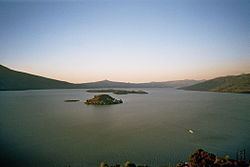
- On lake patzcuaro 06 10 15
- WetlandsEdit
- WatershedEdit
- HistoryEdit
- Islands in the lakeEdit
- Major towns along the lake shoreEdit
- Minor towns along the lake shoreEdit
- Nearby areasEdit
- References
Map of Lake P%C3%A1tzcuaro, Michoac%C3%A1n, Mexico
The natives believe that the lake is the place where the barrier between life and death is the thinnest.
Lake Pátzcuaro lies in an endorheic basin, which does not drain to the sea. A watershed area of 929 square kilometres drains into the lake, of which 126.4 are the water body. The Lake Pátzcuaro watershed extends 50 kilometres east-west and 33 kilometres from north to south. Lake Pátzcuaro lies at an elevation of 1,920 metres, and is the center of the basin and is surrounded by volcanic mountains with very steep slopes. It has an average depth of 5 metres and a maximum of 11. Its volume is approximately 580 million cubic metres.
The Lake Pátzcuaro basin is of volcanic origin. At times it has been part of an open and continuous hydrological system formed by Lake Cuitzeo, Pátzcuaro and Lake Zirahuén, which drained into the Lerma River. Today, like lakes Cuitzeo and Zirahuén, it is a closed basin, although ecologists consider it a sub-basin of the Lerma-Chapala basin.
On lake patzcuaro 06 10 15
WetlandsEdit
The lake is surrounded by extensive wetlands. Cattails and other reedy vegetation are the dominant wetland vegetation, in dense stands over 2 meters tall. Typical wetland plant genera include Typha, Scirpus, Heleocharis, and Cyperus. The dominant species of aquatic vegetation are Potamogeton illinoensis, Scirpus pectinatus, tule (Typha latifolia), T. dominguensis, and Nymphaea mexicana.
The wetlands are extremely important for birds, both year-round inhabitants and migrating waterfowl. Close to 200 species inhabit the wetlands, including some endemic species such as the black-polled yellowthroat (Geothlypis speciosa). Two native species have not been observed recently; the yellow rail (Coturnicops noveboracensis) has not been seen since 1964 and may be locally extinct, and the endemic slender-billed grackle (Quiscalus palustris) is presumed extinct. The Lake Patzcuaro salamander (Ambystoma dumerilii) is endemic to the basin.
The lake and its surrounding wetlands have undergone significant environmental changes over the past 50 years. logging and agriculture in the surrounding watershed have contributed to siltation of the lake (1 cm / year - 1.2 million cubic meters / year), and water diversion for agriculture and urbanization has reduced the size of the lake by 40 square kilometers, and 2.6 meters in depth. Other threats include untreated sewage, the introduction of exotic species, and chemical pollution.
WatershedEdit
In the watershed surrounding the wetlands, the natural terrestrial vegetation is composed of xeric scrub (1,920-2,100 m above sea level), pine and oak forests intertwined with xeric scrub (2,100-2,400 m) and by pure pine-oak forests in the higher peaks (2,400-2,900 m). The pine-oak forests are part of the Trans-Mexican Volcanic Belt pine-oak forests ecoregion.
In the last fifty years, human activity in the watershed has intensified. Farming and livestock ranching in the basin have significantly increased. Over 10,000 hectares of forest have been lost to logging, fires, fuelwood gathering, and clearance for farming and ranching.
HistoryEdit
The Lake Pátzcuaro basin is home to the Purépecha people. Purépecha leaders established the basin as the heartland of the Tarascan state, which rivaled the Aztec Empire before the Spanish conquest. The towns of Ihuatzio, Tzintzuntzan and Pátzcuaro were important Purépecha centers.