
Construction began 1976 Operator(s) Southern Rural Water Creates Lake Narracan Length 109 m Catchment area 1,942 km² | Opening date May 1983 Area 2.81 km² Height 23 m Outflow location Latrobe River | |
 | ||
Total capacity 7,230 megalitres (255×10^ cu ft) Similar Edward Hunter Heritage, Blue Rock Dam, Latrobe Valley, Glenmaggie Dam, Morwell National Park | ||
Lake Narracan is an artificial lake on the Latrobe River built to supply cooling water for the nearby brown coal-fired power stations.
Contents
- Map of Lake Narracan Victoria 3825 Australia
- LocationEdit
- HistoryEdit
- PurposeEdit
- Recreational activitiesEdit
- References
Map of Lake Narracan, Victoria 3825, Australia
LocationEdit
Lake Narracan is located on the Latrobe River in the Latrobe Valley. The dam wall is approximately 1.5 km upstream of the Yallourn Power Station. Its upper reaches are approximately 6 km further to the west, close to where the Narracan Creek meets the Latrobe River. The lake was formerly called the Yallourn Storage Dam.
HistoryEdit
The reservoir was first constructed by the State Electricity Commission of Victoria between 1959 and 1961 and has the capacity of 8,600 megalitres (ML).
In 2002 major works were undertaken to bring the reservoir up to modern day standards, including anchoring the dam wall to the foundation bedrock and strengthening the four gates.
PurposeEdit
The dam supplies water for cooling the generators of the power stations in the Latrobe Valley. This supply is supplemented with water from Blue Rock Lake approximately 15 km upstream on the Tanjil River.
Recreational activitiesEdit
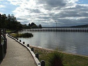
Lake Narracan is also used for recreational purposes, including waterskiing, jet skiing, swimming, recreational fishing, and bush walking on the shore. A school camp (Woorabinda) on the northern shore of the lake offers facilities for around 75 people. On the southern shore there is a caravan park and campground. The Moe Golf Club is also located on the south shore with a number of holes overlooking Lake Narracan.
The Latrobe Valley Model Aero Club is also located on the lake shore. The Victoria Branch of the Australian Hovercraft Federation use the west end of the lake. The Moe Yallourn Rail Trail passes close by the southern shore of the lake.
It is also the largest fresh water lake that is not used for domestic water storage in Victoria.