
Max. length 16 kilometres (9.9 mi) Length 16,000 m Max width 3,500 m Province Québec | Primary inflows Surface elevation 395 m Area 26.4 km² Mean depth 75 m | |
 | ||
Cities Lac-Mégantic, Frontenac, Quebec | ||
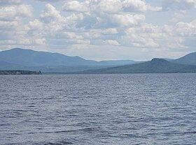
Lake Mégantic (French: Lac Mégantic) is a body of water in Québec, located in the Appalachian Mountains near the U.S. border. It is a source of the Chaudière River which drains into the St Lawrence River at Québec City. The name Mégantic means 'where the fish gather' in the Abénaquis language. The lake has a surface area of 26.4 km2 (10.2 sq mi) with several villages and small towns on its shores, including Lac-Mégantic, Frontenac, Marston, and Piopolis. It is part of Le Granit Regional County Municipality, a rural region where forestry and granite extraction are important activities.
Contents
Map of Lac M%C3%A9gantic, Qu%C3%A9bec, Canada
Physical geographyEdit
The water surface is 395 m (1,296 ft) above mean sea level and the lake has an average depth of 75 m (246 ft); its total surface area is 26.4 square kilometres (10.2 sq mi), with a total shoreline of 45.4 km (28.2 mi). Its length is about 16 km (9.9 mi) and it has an average width of 3.5 km (2.2 mi).
European settlementEdit
Settlement under the French régime was sparse. It was not until the 19th century that significant numbers of settlers arrived, including many Scots who had been forced to leave their ancestral home in the Highlands.