
 | ||
Lake Lewis was a temporary lake in the Pacific Northwest region of North America, largely formed by the Missoula Floods in about the 14th millennium B.C.
Contents
- Map of Lake Lewis Washington 99323 USA
- Glacial Lake Missoula
- Wallula Gap
- Touchet Formation
- Glacial erratics
- References
Map of Lake Lewis, Washington 99323, USA
Lake Lewis was formed when the restricted flow of waters from periodic cataclysmic floods from Glacial Lake Missoula, pluvial Lake Bonneville, and perhaps from subglacial outbursts, backed up through the constriction formed by the Wallula Gap in the Horse Heaven Hills (southern Washington). Water also backed up further downstream on the Columbia River between Washington and Oregon, delaying the drainage of Lake Lewis. The water remained for a period of weeks before the flood waters drained through Wallula Gap, just southeast of the Tri-Cities area. Lake Lewis reached an elevation of about 1,200 feet (370 m) above sea level (today's sea level) before subsiding.
Lake Lewis also flooded the Yakima, Walla Walla, Touchet and Tucannon river valleys.
Glacial Lake Missoula
During the last ice age (18,000 to 12,000 years ago), and in multiple previous glacial ages, cataclysmic floods inundated portions of the Pacific Northwest from Glacial Lake Missoula, pluvial Lake Bonneville, and perhaps from subglacial outbursts. Glacial Lake Missoula was a body of water as large as some of the USA's Great Lakes. This lake formed from glacial meltwater that was dammed by a lobe of the Canadian ice sheet. Episodically, perhaps every 40 to 140 years, the waters of this huge lake forced its way past the ice dam, inundating parts of the Pacific Northwest. Eventually, the ice receded northward far enough that the dam did not reform, and the flooding episodes ceased.
Wallula Gap
Wallula Gap is a large water gap through basalt anticlines in the Columbia River basin just south of the confluence of the Walla Walla River and the Columbia River. The Wallula Gap, which has existed for many millions of years, was widened by the historic flow of the Salmon-Snake and Columbia Rivers combined with the glacial waters that poured across the Channeled Scablands during the Missoula Floods. The Wallula Gap constrained the flow such that less than 1/5 of the 800 km³ of water per day entering could be discharged. As a result, the floods filled the Pasco Basin and formed, for a short period, Lake Lewis. The large volumes of flood water passing through the gap contributed substantially to the erosion of the gap, as is evidenced by the shear walls and of scab-features such as the "Sisters."
Touchet Formation
Lake Lewis backflooded into the Yakima, Walla Walla, Touchet and Tucannon River Valleys. In these relatively calm arms of the lake, the slackwaters were thick with suspended materials eroded from the scablands above. Some of the suspended materials settled out, creating thick Touchet Formation layers which are found throughout these valleys.
Glacial erratics
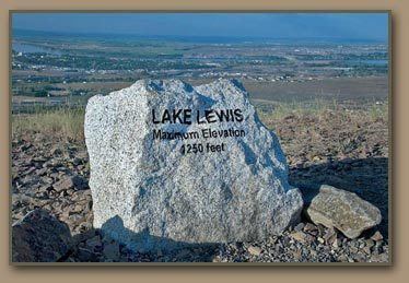
The maximum elevation of the flood, as established by other indications, is confirmed by glacial erratics, which were stranded on the slopes of the Horse Heaven Hills and other elevated regions in the mid-Columbia at elevations of up to 1,200 feet (370 m) above sea level. There were several long ridges (Saddle Mountains, Frenchman Hills, and Rattlesnake Mountain) that were above flood level. Peaks like the Badger, Candy, and Red Mountains were islands. At this level, much of the Columbia Basin would have been submerged.