
Primary outflows Soro River Max. length 19 km (12 mi) Surface elevation 808 m Length 19 km Catchment area 250 km² | Max. width 4.5 km (2.8 mi) Area 49.24 km² Width 4.5 km | |
 | ||
Primary inflows | ||
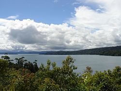
Heading to wasami island lake kutubu png
Lake Kutubu is a lake in the Southern Highlands Province of Papua New Guinea. It lies to the east of the Kikori River, into which it eventually drains. It is about 50 km southwest of Mendi, the provincial capital. It is one of the few lakes in the country that occurs in a depression in the rugged interior mountains. It is the second-largest lake in Papua New Guinea, after Lake Murray, and, at 800 m above sea level, the largest upland lake. The area of the lake is 49.24 km², while the total catchment area is 250 km². Lake Kutubu and Lake Sentani form an ecoregion on the WWF's Global 200.
Contents
- Heading to wasami island lake kutubu png
- Map of Lake Kutubu Papua New Guinea
- Fauna
- Conservation
- References
Map of Lake Kutubu, Papua New Guinea
The lake has a few islands, the largest of which is Wasemi Island in its northern part. The water of Lake Kutubu is clear, and the lake reaches a depth of 70 m (230 feet). It is fed by several streams, most of its contents come from underground sources. The catchment is inhabited by two main ethnic groups, the Foe to the south and the Fasu to the north. Thirty-three villages lie in the catchment area, with a total estimated population of 10,885.
The lake gave its name to the nearby Kutubu Oil Project, Papua New Guinea's first commercial oilfield development, operated by Oil Search Limited, and which began production in 1992. The development has supported the local economy, and caused a general in-migration to the area, and ecological problems resulting from rapid population growth, including pollution, forest destruction and overfishing. A proposed gas pipeline and road are expected to exacerbate these problems unless they are well-managed.
Fauna
Lake Kutubu includes 13 endemic fish species, making it the most unusual lacustrine habitat for fishes in the New Guinea-Australia region. The endemic fish species are:
Additionally, the Parastacid crayfish Cherax papuanus is endemic to the lake.
Conservation
Because of its biodiversity and ecological significance, the area has been designated a "Wetland of International Significance" by the Ramsar Convention. The area included in this designation matches the Lake Kutubu Wildlife Management Area (240.57 km²). The area is undergoing study by the World Wildlife Fund and the drafting of a catchment management plan has commenced, which is anticipated to become a model for other catchments in Papua New Guinea. The project is to be completed by December 2007. The Lake Kutubu area is also included in the tentatively listed Kikori River Basin - Great Papuan Plateau World Heritage Site.