
Max. width 18 km (11 mi) Area 647 km² Length 63 km Shore length 2,038 km | Max. length 63 km (39 mi) Surface area 647 km (250 sq mi) Surface elevation 59 m Width 18 km | |
 | ||
Primary inflows Outflow location Fly River, Gulf of Papua, Strickland River | ||
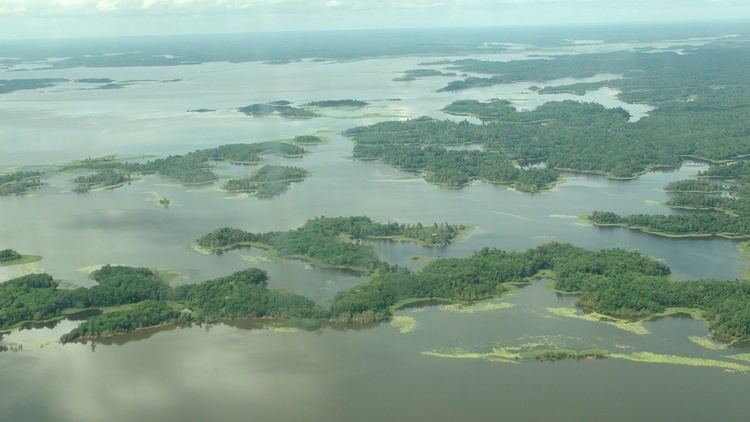
Lake Murray is the largest lake in Papua New Guinea. It is located in the Middle Fly District, Western Province at 7°S 141.5°E / -7; 141.5, which covers approximately 647 km² and in the wet season increases to five times the size. It has a highly convoluted shoreline more than 2000 km long. The lake has been a source of nourishment for many of the local peoples. Freshwater sawfish have been caught in its shallow waters to feed the crocodiles in a farming operation.
Contents
- Map of Lake Murray Papua New Guinea
- Illegal logging
- Greenpeace Global Forest Rescue Station GFRS
- References
Map of Lake Murray, Papua New Guinea
Indigenous tribes of around 5000 people own the lake and the surrounding one million hectares of forest.
Also, a cryptid known as "Murray" purportedly lives, or used to live, in the lake. This creature was described as resembling a theropod dinosaur such as Tyrannosaurus.. Along with the "Murray", Lake Murray is known for a large population of Peacock Bass that were introduced by Indian merchants.
Illegal logging
In 2003, logging company Concord Pacific was forced out of the area by Greenpeace and other NGO's. 100,000 hectares of ancient forest was degraded by the logging along the Kiunga-Aiambak road.
Greenpeace Global Forest Rescue Station (GFRS)
Lake Murray was the site of a Greenpeace Australia Pacific Global Forest Rescue Station. Forty volunteers from 25 countries worked with the local Kuni, Begwa and Pari tribes to identify and mark land ownership. The boundary marking was the precursor to a community based eco-forestry project. Ecotimber has since been harvested, shipped to Australia and sold with the benefit of Forestry Stewardship Council certification.