
Surface area 10.7 km (4.1 sq mi) Surface elevation 822 m Volume 0.13 km³ | Max. depth 30.5 m (100 ft) Area 10.7 km² Shore length 31.5 km | |
 | ||
Water volume 0.13 km (110,000 acre·ft) Similar Mount Bandai, Goshiki‑numa, Akimoto Lake, Lake Inawashiro, Lake Nojiri | ||
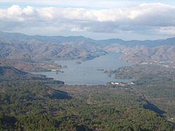
Lake Hibara (桧原湖, Hibara-ko) is a lake located in Yama District, Fukushima, Japan. It is a part of the Bandai-Asahi National Park and is the largest of the lakes in the Bandai-kōgen highlands.
Contents
- Map of Lake Hibara Hibara Kitashiobara Yama District Fukushima Prefecture 966 0400 Japan
- Formation
- Recreation
- References
Map of Lake Hibara, Hibara, Kitashiobara, Yama District, Fukushima Prefecture 966-0400, Japan
Formation
A mesotrophic lake, Lake Hibara was formed as a result of the July 15, 1888 eruption of Mount Bandai. The resulting debris avalanche created a natural dam that then filled with water, submerging Hibara Village (桧原村, Hibara-mura). The remains of Hibara Village still lie at the bottom of the lake.
Recreation
A tourist industry has built up around Lake Hibara, offering hiking trails, pleasure cruises, and campgrounds and other lodging. In the winter, ice fishing is popular.
References
Lake Hibara Wikipedia(Text) CC BY-SA