
Max. length 34 mi (55 km) Surface area 20,000 acres (81 km) Max depth 29 m Length 54.71 km | Max. width 1.3 mi (2.1 km) Area 82.15 km² Surface elevation 61 m | |
 | ||
Fish Striped bass, Largemouth bass, Walleye, Bluegill, Channel catfish, Blue catfish, Chain pickerel Islands Wobble Island, Goat Island | ||
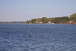
Lake Gaston is a hydroelectric reservoir in the eastern United States. Part of the lake is in the North Carolina counties of Halifax, Northampton, and Warren. The part extending into Virginia lies in Brunswick and Mecklenburg counties. Lake Gaston is roughly 35 miles (56 km) long and covers over 20,000 acres (81 km2), with 350 miles (560 km) of shoreline.
Contents
- Map of Lake Gaston United States
- Lake level and water managementEdit
- Community associationEdit
- Real estateEdit
- Waterfront construction authorityEdit
- Major on water marinasEdit
- Marine supply and boat dealersEdit
- Boating regulationsEdit
- ControversiesEdit
- References
Map of Lake Gaston, United States
The area surrounding the lake is home to more than 150,000 residents. The nearest towns are Littleton and Roanoke Rapids in North Carolina, and Clarksville and South Hill in Virginia.
The lake is not federally owned. It was formed when the Virginia Electric Power Company (VEPCO) built Gaston Dam on the Roanoke River to generate electricity for Dominion Resources, which owns the lake. The dam is located on the North Carolina side and generates electricity for Dominion North Carolina Power, which is the North Carolina operating company of Dominion Resources. The dam includes four hydroelectric generators, with a total generating capacity of 224 megawatts.
Lake Gaston is fed by water from Kerr Lake upstream, and supplies water to Roanoke Rapids Lake downstream, a smaller predecessor to Lake Gaston. This is one of the few areas of the country with three hydroelectric dams so close together.
Lake Gaston has long been popular for fishing and other water recreation. The lake is a favorite vacation spot, because it is close to the Research Triangle region of North Carolina and is close to I-85 and I-95. Lake Gaston was built for flood control, hydroelectric power and recreational enjoyment, including activities such as fishing, boating, swimming, water skiing and wakeboarding.
The lake has been a popular retirement destination since the 1970s.
Lake level and water managementEdit
Lake Gaston differs from many other lakes in that the water levels are strictly regulated through a license with the Federal Energy Regulatory Commission (FERC). The license also requires cooperation with the U.S. Army Corps of Engineers, which manage the upstream feeder lake, Lake Kerr. There are four defined operating conditions for Lake Gaston:
As a result of controlled lake levels, fixed docks and boat houses are normal on Lake Gaston.
Community associationEdit
The Lake Gaston Association (LGA) is a citizens' organization that actively advocates and promotes the interests of households and businesses who own property in the two states and five counties of Lake Gaston. Each of the five counties surrounding Lake Gaston has four volunteer Director positions on the LGA Board, plus one at-large position, for a total of 25 Directors. It is a volunteer, non-profit, nonpartisan and nonsectarian organization, unified for greater influence with federal, state and local officials and agencies that have management authority on and around Lake Gaston.
Real estateEdit
Lake Gaston covers an extended geographical area and is bordered by several towns. Real estate is generally broken up via quadrant, and realtors will use the terms "South-East", "South-West", "North-East", and "North-West" when discussing general location of a property on the lake.
Waterfront construction authorityEdit
Generally speaking, no individual owns waterfront property on Lake Gaston because Dominion Power owns the lake and the land up to the "High Water Mark". Real estate is listed with an indicator which tells the buyer how many linear feet of property they would own which abuts to the High Water Mark. This number used to be referred to as the "HWM" on real estate listings, and is now referred to as "DOM". However, Dominion Power does allow for construction of boat houses and other permitted structures through an approval process.
Major on-water marinasEdit
By quad:
Marine supply and boat dealersEdit
Boating regulationsEdit
The North Carolina part of the lake is controlled by the Wildlife Resources Commission. The Virginia side is regulated by the Department of Game and Inland Fisheries.
ControversiesEdit
After many years of court battles, the Virginia Beach area was able to operate an over-70-mile (110 km) water pipeline from Lake Gaston to Virginia Beach and its surrounding areas for the purpose of providing drinking water.