Country United States GNIS feature ID 453534 Area 215.8 km² Population 2,894 (2010) | Elevation 204 m Local time Saturday 1:19 AM | |
 | ||
ZIP codes 46702, 46941, 46990, 46992 Weather -7°C, Wind N at 2 km/h, 64% Humidity Points of interest Salamonie Lake Dam, Kokiwanee Nature Preserve, Hanging Rock, Hathaway Preserve At Ross Run, Salamonie State Forest | ||
Lagro Township is one of seven townships in Wabash County, Indiana, United States. As of the 2010 census, its population was 2,894 and it contained 1,214 housing units.
Contents
- Map of Lagro Township IN USA
- History
- Geography
- Cities towns villages
- Unincorporated towns
- Adjacent townships
- Cemeteries
- Rivers
- Lakes
- School districts
- Political districts
- References
Map of Lagro Township, IN, USA
History
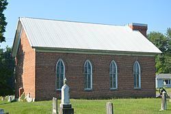
The Hominy Ridge Shelter House and Hopewell Methodist Episcopal Church and Cemetery are listed on the National Register of Historic Places.
Geography
According to the 2010 census, the township has a total area of 83.33 square miles (215.8 km2), of which 81.24 square miles (210.4 km2) (or 97.49%) is land and 2.09 square miles (5.4 km2) (or 2.51%) is water.
Cities, towns, villages
Unincorporated towns
(This list is based on USGS data and may include former settlements.)
Adjacent townships
Cemeteries
The township contains these seven cemeteries: Center Grove, Foster, Independent Order of Odd Fellows, Leedy, Renicker, Saint Patrick and Speicher.
Rivers
Lakes
School districts
Political districts
References
Lagro Township, Wabash County, Indiana Wikipedia(Text) CC BY-SA
