
Named for Marquis de La Fayette Founded 1820 Unemployment rate 5.3% (Apr 2015) | Area 1,655 km² Population 32,943 (2013) | |
 | ||
Website www.lafayettecountymo.com Colleges and Universities Wentworth Military Academy and College, Lex La-Ray Technical Center Points of interest Battle of Lexington State Hist, Confederate Memorial State Hist, Lexington Historical Museum, La Bella Vineyards & Winery | ||
Lafayette County is a county located in the western portion of the U.S. state of Missouri. As of the 2010 census, the population was 33,381. Its county seat is Lexington. The county was organized November 16, 1820 from Cooper County and originally named Lillard County for James Lillard of Tennessee, who served in the first state constitutional convention and first state legislature. It was renamed Lafayette County on February 16, 1825, in honor of Revolutionary War hero the Marquis de La Fayette, who was then visiting the United States.
Contents
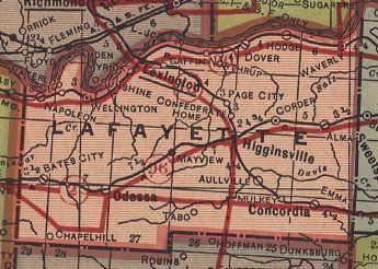
- Map of Lafayette County MO USA
- History
- Geography
- Adjacent counties
- Major highways
- National protected area
- Demographics
- Public schools
- Private schools
- Local
- State
- Federal
- Missouri Presidential Preference Primary 2008
- References
Map of Lafayette County, MO, USA
Lafayette County is part of the Kansas City, MO-KS Metropolitan Statistical Area.
History
Lafayette County was settled primarily from migrants from the Upper Southern states of Kentucky, Tennessee and Virginia. They brought slaves and slaveholding traditions and started cultivating crops similar to those in Middle Tennessee and Kentucky: hemp and tobacco. As a result, this part of Missouri, and neighboring counties, became known as Little Dixie. In 1860 slaves made up 25 percent or more of the county's population, and the county was strongly pro-Confederate during the American Civil War.
Newcomers from Germany as well as German Americans from St. Louis began arriving shortly before the war, with many more to come afterwards. They eventually made up a large part of the populations of Concordia, Emma, Wellington, Napoleon, Higginsville, Mayview, and Lexington. The German immigrants generally supported the Union during the war.
In November 2013, Leland Ray Kolkmeyer pleaded guilty, in federal court, of a fraud scheme in which he embezzled more than $1.5 million from Wellington-Napoleon Fire Protection District and Special Road District while being their former treasurer.
Geography
According to the U.S. Census Bureau, the county has a total area of 639 square miles (1,660 km2), of which 628 square miles (1,630 km2) is land and 11 square miles (28 km2) (1.6%) is water.
Adjacent counties
Major highways
National protected area
Demographics
As of the census of 2000, there were 32,960 people, 12,569 households, and 9,099 families residing in the county. The population density was 52 people per square mile (20/km²). There were 13,707 housing units at an average density of 22 per square mile (8/km²). The racial makeup of the county was 95.52% White, 2.27% Black or African American, 0.29% Native American, 0.25% Asian, 0.03% Pacific Islander, 0.51% from other races, and 1.12% from two or more races. Approximately 1.17% of the population were Hispanic or Latino of any race. 37.3% were of German, 17.5% American, 9.9% English and 9.7% Irish ancestry.
There were 12,569 households out of which 33.90% had children under the age of 18 living with them, 59.30% were married couples living together, 9.40% had a female householder with no husband present, and 27.60% were non-families. 24.00% of all households were made up of individuals and 11.20% had someone living alone who was 65 years of age or older. The average household size was 2.55 and the average family size was 3.01.
In the county, the population was spread out with 26.20% under the age of 18, 7.60% from 18 to 24, 27.50% from 25 to 44, 23.30% from 45 to 64, and 15.40% who were 65 years of age or older. The median age was 38 years. For every 100 females there were 95.90 males. For every 100 females age 18 and over, there were 92.00 males.
The median income for a household in the county was $38,235, and the median income for a family was $45,717. Males had a median income of $31,972 versus $22,684 for females. The per capita income for the county was $18,493. About 6.90% of families and 8.80% of the population were below the poverty line, including 10.90% of those under age 18 and 9.10% of those ages 65 or over.
Public schools
Private schools
Local
The Republican Party mostly controls politics at the local level in Lafayette County. Republicans hold a little more than half of the elected positions in the county.
State
Lafayette County is divided into four legislative districts in the Missouri House of Representatives, three of which are held by Republicans and one by a Democrat.
All of Lafayette County is a part of Missouri’s 21st District in the Missouri Senate and is currently represented by Bob Stouffer (R-Napton).
Federal
All of Lafayette County is included in Missouri’s 5th Congressional District, which is currently represented by Emanuel Cleaver (D-Kansas City) in the U.S. House of Representatives. Prior to redistricting following the 2010 United States Census, all of Lafayette County was included in Missouri's 4th Congressional District.