
- location Mt. Pleasant Twp. - location Creamtown Basin area 1,549 km² Basin area 1,549 km² | - elevation 1,840 ft (561 m) - elevation 1,480 ft (451 m) Length 50 km Discharge 37.32 m³/s | |
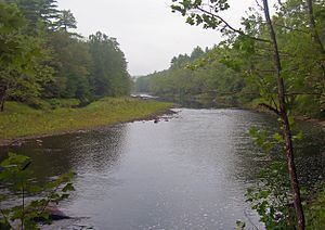 | ||
The Lackawaxen River is a 31.3-mile-long (50.4 km) tributary of the Delaware River in northeastern Pennsylvania in the United States. The river flows through a largely rural area in the northern Pocono Mountains, draining an area of approximately 598 square miles (1,550 km2).
Contents
Map of Lackawaxen River, Pennsylvania, USA
Its source is in the borough of Prompton in western Wayne County, at the confluence of the West Branch and Van Auken Creek. It flows past Honesdale and Hawley, where it is joined from the southwest by Wallenpaupack Creek. It continues east and joins the Delaware at Lackawaxen. East of Honesdale, it was deepened as part of the Delaware and Hudson Canal project.
The river is a popular destination for canoeing and recreational fly fishing for trout. It was reportedly where the American author Zane Grey first learned to fly fish.
West Branch Lackawaxen RiverEdit
The West Branch, approximately 21.5 miles (34.6 km) long, rises from a confluence of several small streams in the villages of Orson and Poyntelle in northern Wayne County, and flows south-southeast through Belmont Lake in Belmont Corners. After a second confluence, with Johnson Creek, it flows southeast through Prompton Lake reservoir, to a third confluence, with Van Auken Creek, to form the main stem.