
Country Belgium Area codes 09 Postal code 9270 Area code 09 | Postal codes 9270 Website www.laarne.be Local time Friday 4:00 PM | |
 | ||
Weather 12°C, Wind SE at 10 km/h, 51% Humidity Governing parties Open Vlaamse Liberalen en Democraten, Socialistische Partij Anders | ||
Laarne ( [ˈlaːrnə]) is a municipality located in the Belgian province of East-Flanders. The municipality comprises the towns of Kalken and Laarne proper. On January 1, 2006, Laarne had a total population of 11,736. The total area is 32.07 km² which gives a population density of 366 inhabitants per km². The current mayor of Laarne is Ignace De Baerdemaecker, from the VLD (Liberal) party.
Contents
Map of Laarne, Belgium
History
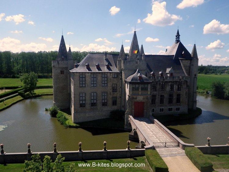
The village lies to the east of Ghent, near a former course of the River the Scheldt and is notable for its castle. The castle dates from the twelfth and later centuries, notably, the seventeenth, and has been sympathetically restored and re-furnished.
The name arises from the Germanic hlaeri which signifies terrain seen as wooded and marshy. It is possible to speculate that the village originated in serving the castle, which in turn, guarded the river approach to Ghent from the sea. In the twelfth century, the river was less remote from the city than it is today. In 1040, Laarne was mentioned as Laren.
The lordship passed by inheritance through the families of Schoutheete, Van Vilsteren and others, finally to the counts of Ribaucourt. The castle is now owned by the Vereniging van Historische Woonsteden van België (the Union of Historic Homesteads of Belgium).