
Municipality since 1921 Local time Thursday 6:35 PM | Department Lempira Area 109 km² Population 6,539 (2015) | |
 | ||
Weather 21°C, Wind N at 18 km/h, 71% Humidity | ||
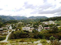
La Campa is a municipality and an aldea, or small town, in the Honduran Department of Lempira, located about 18 kilometres (11 mi) by dirt road from Gracias, the largest town in the immediate region.
Contents
Map of La Campa, Honduras
The inhabitants of Gracias, La Campa, and other nearby aldeas, including San Manuel Colohete, are mainly of Lenca descent. Although the aldea is small, there are multiple smaller and spread out satellite communities in the hills above La Campa, such as Cruz Alta. These communities grow coffee to consume and sell; substance crops of rice, mango, a dozen varieties of bananas, and black beans; and run their own public elementary schools and churches.
The town is known as a centre of Lenca pottery production, of which there are two main styles; there are black and white (smoked) pots and red-glazed pots. La Campa's are of the latter style. Much of the pottery sold in La Campa is brought down from the hillside villages, where the villagers are adept pottery makers. The town also has a large 18th-century Spanish church. La Campa sits in a deep river valley near Montaña Celaque (a.k.a. Cerro Las Minas), the tallest mountain in Honduras.
History
La Campa in 1582 was a small town with 20 tributaries to encomendero Mario Cana. It was previously known as "Tecauxinas", back in 1887 it was a village of Gracias. It became a municipality in 1921. The name of "La Campa" has its origins in an expression used by old miners, it had to do with searching protection against the rain.
Geography
It is located on a hillside and it is guarded by a line of solid rock hills covered with pine forests. The weather is cool and temperate most of the year.
Boundaries
Its boundaries are:
The municipal boundaries cover some 172 square kilometres (42,502 acres) in land area.
Population
Half of the people in La Campa have cross-breed traits and the other half are descendants of native Indians. These last are especially seen in the surrounding villages.
In 2001 the population of La Campa municipality was 4,238. The National Intitue of Statistics projected a population increase to reach in excess of 5 thousand inhabitants by 2008.
The La Campa municipality contains 5 designated villages, and 49 other named settlements.
Tourism
There are many visits to this place organised by some hotels in Gracias. It is part of "Colosuca" trail and its well preserved church is one of the attractions.
"San Matias" day is a local holiday and festival period, running from 15 to 28 February.