
Area 10.02 km² | Elevation 15 m | |
 | ||
Island groups Ryukyu Islands, Yaeyama Islands | ||
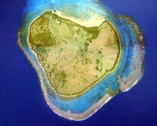
Kuroshima (黒島; Yaeyama: Fishiima Okinawan: Kurushima), also known as "Kuro Island", is an island in Taketomi Town, Okinawa, part of the Yaeyama archipelago. The island has the approximate shape of a heart symbol when viewed from the air, and is marketed as "Heart Island". The name means "Black Island".
Contents
- Map of Kuroshima Taketomi Yaeyama District Okinawa Prefecture 907 1311 Japan
- Sights
- Infrastructure
- References
Map of Kuroshima, Taketomi, Yaeyama District, Okinawa Prefecture 907-1311, Japan
The island has an area of some 100 km2 (39 sq mi)and a population of approximately 210 as of 2006. Kuroshima is a comparatively flat island, as the highest point is just 15 metres (49 ft) above sea level.
Cattle raising is a major economic activity and a yearly "cow festival" is held. Sometimes the island is marketed as "Island of Cows" as well, as there are more cows than inhabitants living on it. Tourist activities include diving and sunbathing.
Sights
Kuroshima has various sights to offer:
the banana trees vegetate and bear fruit on the island helped by high temperatures
Infrastructure
Kuroshima can be reached by ferry from Ishigaki several times a day. Bikes are for hire at the small harbour in the north of the island. All the sights can easily be reached on foot. There several guest houses (minshuku) on Kuroshima. In the village, there is a shop and a post offices which serves as a bank as well