
Coastline 14.8 km (9.2 mi) Elevation 60 m | Adjacent bodies of water Pacific Ocean Highest elevation 59.5 m (195.2 ft) Area 12.73 km² | |
 | ||
Island groups Ryukyu Islands, Yaeyama Islands | ||
A short trip in hateruma island
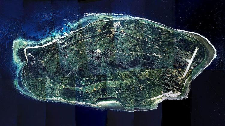
Hateruma (波照間島; Hateruma-jima; Yaeyama: Hatirooma Okinawan: Hatiruma) is an island in the Yaeyama District of Okinawa Prefecture, Japan. Part of the town Taketomi, it is the southern-most inhabited island in Japan at 24°2’25” north latitude, 123°47’16” east longitude. Hateruma is one of the Yaeyama Islands, and is located 24 kilometres (15 mi) south of Iriomote-jima, the largest of the island group.
Contents
- A short trip in hateruma island
- Map of Hateruma Taketomi Yaeyama District Okinawa Prefecture 907 1751 Japan
- Ishigaki island hateruma island
- Sights
- Climate
- Infrastructure
- References
Map of Hateruma, Taketomi, Yaeyama District, Okinawa Prefecture 907-1751, Japan
Hateruma, which is composed of corals, has 12.7 km² of area and approximately 600 inhabitants.
The primary products of the island include sugarcane, pineapple, refined sugar, and Awanami, a highly prized type of the alcoholic beverage awamori. Its southern location makes it one of the few places in Japan where the Southern Cross can be observed.
Ishigaki island hateruma island
Sights
Hateruma is visited by a comparatively high number of Japanese tourists from Ishigaki on day trips, as it boasts the southernmost tip of land of Japan. In addition, the southernmost school and the southernmost police station of Japan are tourist attractions. Further places of interest include:
Climate
Because of Hateruma's extremely southern proximity, the climate in the island has been considered as part of the standards of a subtropical climate, and enjoys a much warmer weather compared to the rest of the main islands of Japan. Because of it's geographical location, being both subtropical and a small island itself, the island shares both oceanic and tropical characteristics. But in terms of meteorology, the Köppen climate classification system classifies the local climate as "humid subtropical climate" (Cfa).
Infrastructure
Hateruma Airport is located on the island but is not currently served by any commercial flights. Haterujima is easily accessible by ferry from Ishigaki several times a day. There are several guest houses and some shops and restaurants on the island. Bikes are for hire at the harbour.