
District Wiener Neustadt-Land Vehicle registration WB Elevation 533 m Population 2,240 (1 Apr 2009) Postal code 2851 | Time zone CET (UTC+1) Website www.krumbach-noe.at Area 43.91 km² Local time Saturday 1:33 PM Area code 02647 | |
 | ||
Weather 10°C, Wind SE at 6 km/h, 78% Humidity | ||
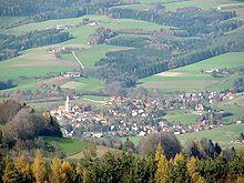
Krumbach is a market town in southern Lower Austria, Austria. It is part of the landscape Bucklige Welt.
Contents
Map of Krumbach, Austria
History
Archaeological artifacts from the Stone Age, the Bronze Age and the Roman times have been found in the area. In 1182, Krumbach was mentioned for the first time in writing. The present castle Schloss Krumbach was erected in the 13th century. In 1394 Hans von Chrumbach, the last Lord of Krumbach, died and left the castle to his maternal uncle.
In the 17th and 18th centuries, the plague and the cholera affected Krumbach. In 1854, it became a market town. In 1884, Krumbach opened a fire station. It has a post office, a school (Volksschule Krumbach), a high school (Hauptschule Krumbach) and a church.
Coat of arms
The coat of arms shows a silver lion with a chain around its neck. The crest is colored red. This has been the town's seal since January 19, 1957.
Sites of interest
Buildings:
Parks: