
Length 285 km Source elevation 358 m | - min 5 m/s (177 cu ft/s) Basin area 10,875 km² | |
 | ||
- location Sop Kok, Wiang Chai, Chiang Rai Province - average 120 m/s (4,238 cu ft/s) - max 848 m/s (29,947 cu ft/s) Similar Wat Rong Khun, Wat Phra That Doi Chom Th, Ruak River, Doi Tung, Wat Phra Kaew - Chiang Rai | ||
Boat ride on the mae kok river to chiang rai thailand part 1
The Kok River (Thai: แม่น้ำกก, rtgs: Maenam Kok, [mɛ̂ːnáːm kòk]) flows in Southeast Asia.
Contents
- Boat ride on the mae kok river to chiang rai thailand part 1
- Map of Kok River Thailand
- Course
- Tributaries
- Boating and rafting
- Dams
- Top Gear
- References
Map of Kok River, Thailand
Course
The river originates in the Daen Lao Range, Shan State, Burma. It flows eastwards across the Myanmar-Thailand border, coming in at the Thai border town of Tha Ton (Thai: ท่าตอน, also spelled Thaton ). It flows to Mae Ai district, Chiang Mai Province. Most of its length in Thailand is in Chiang Rai Province where it passes Mueang Chiang Rai District after which it bends northeastwards and flows through Mae Chan, Wiang Chai and Chiang Saen districts.
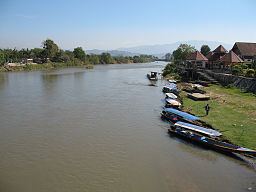
It is a wide, shallow, and slow-moving river. There is about 600 metres (2,000 ft) of small-scale whitewater halfway between the towns of Taton and Chiang Rai. Alongside the Mae Kok river, an hour's boat ride upstream from Chiang Rai town, is a touristy "elephant camp" on its north shore.
For several kilometres downriver from Chiang Rai, the river becomes a lake, until it reaches the irrigation dam near Wiang Chai.
The Kok River is a tributary of the Mekong River, with its mouth at Sop Kok in Chiang Saen district, opposite the Lao border.
Phahonyothin Road crosses this river near Chiang Rai City. Altogether, there are five bridges crossing the Mae Kok river near Chiang Rai city.
Tributaries
The main tributaries of the Kok River are the Fang and the Lao River, the latter having its source in the Phi Pan Nam Range.
Boating and rafting
Small long-tail boats ply the Mae Kok between the towns of Taton and Chiang Rai. Boomerang Park is gearing up to start, in 2013, to offer low-cost rafting trips along the Mae Kok river.
Dams
There is a small dam with 11 gates which provides irrigation for rice fields east of Chiang Rai. The dam is 11 kilometres (7 mi) miles east of the Hwy 1 bridge. It turns the river into a lake, several miles long, for eight months of the year. Additionally, there is a dam planned on the Burmese side of where the river flows into Thailand, about 32 kilometres (20 mi) upstream from the border.
Top Gear
In October 2013 the cast and crew of the British television show Top Gear constructed a bridge over the river Kok as part of their Burma Special. The bridge was originally planned to be built over the River Kwai, but the River Fang which flows into the River Kok was chosen "accidentally". The show aired in two parts on 9 March 2014 and 16 March 2014.