
Country Belgium Area codes 051 Postal code 8680 | Postal codes 8680 Website www.koekelare.be Local time Thursday 6:02 PM Area code 051 | |
 | ||
Weather 14°C, Wind W at 11 km/h, 70% Humidity Governing parties Socialistische Partij Anders, New Flemish Alliance | ||
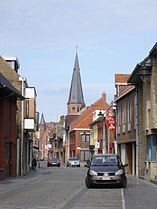
Koekelare ( [ˈkukəlaːrə]) (West Flemish: Kookloare) is a municipality located in the Belgian province of West Flanders. The municipality comprises the towns of Bovekerke, Koekelare proper and Zande. On January 1, 2006 Koekelare had a total population of 8,291. The total area is 39.19 km² which gives a population density of 212 inhabitants per km².
Contents
Map of 8680 Koekelare, Belgium
Koekelare was formerly written as Couckelaere.
Towns
The municipality comprises Koekelare proper, but also contains the villages Bovekerke, Zande and De Mokker. Bovekerke and Zande are "deelgemeentes", who were independent municipalities until the 70s; De Mokker is part of Koekelare proper.
Source :Streekplatform Westhoek. Socio-economische beleidsvisie & hefboomprojecten voor de Westhoek
Koekelare borders the following villages: