
Area 21 km² | Time zone ICT (UTC+7) Population 1,382 (2006) | |
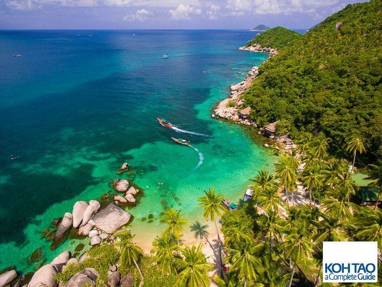 | ||
Ko Tao (also often Koh Tao, Thai: เกาะเต่า, [kɔ̀ʔ tàw], lit. "Turtle Island") is an island in Thailand and forms part of the Chumphon Archipelago on the western shore of the Gulf of Thailand. It covers an area of about 21 km². Administratively it forms a district (amphoe) (as of 2013) of Surat Thani Province. As of 2006 its official population was 1,382. The main settlement is Ban Mae Hat.
Contents
- Map of Ko Tao Ko Pha ngan District Surat Thani Thailand
- History
- Environment
- Tourism
- Crimes
- Population
- Transportation
- Ferries
- Air
- Rail
- References
Map of Ko Tao, Ko Pha-ngan District, Surat Thani, Thailand
The economy of the island is almost exclusively centred on tourism, especially scuba diving.
History
Initially the island was uninhabited, with only the occasional fisherman from the neighbouring islands, looking for shelter in a storm or just resting before continuing on his journey.
It would appear from old maps and descriptions that this island was known by European cartographers and mariners as "Pulo Bardia", indicating that it was first settled by Malayo-Polynesian peoples. The old maps show a chain of three islands aligned north-south and lying off the east coast of the Malay Peninsula. The most northerly and smallest of these islands is marked P. Bardia, the name it had until the early 1900s. The best map example is by John Thornton from The English Pilot, the Third Book, dated 1701, but the specific map of the Gulf of Siam is dated around 1677. Also see maps of the East Indies by William Dampier c.1697. By modern standards of accuracy, the islands are poorly placed on early maps. Seventeenth century marine navigation and cartography used the "backstaff" which, in this area, was accurate to one degree of longitude, or around 60 nautical miles.
The Edinburgh Gazetteer, or Geographical Dictionary published in 1827 also mentions the island and provides a geographical position. In his 1852 book titled Narrative of a Residence in Siam. by Frederick Arthur Neale, the author describes the people and wildlife of Bardia. According to the account there were farms and even cows in a village on the bay lying on the west side of the island. The book includes a fanciful illustration of "Bardia" showing huts and palm trees.
Joseph Huddart in 1801 included these directions for navigating the islands, "To the N.W. by N are two islands of about the same height as Poolo Carnom [Ko Samui]; the first, called SANCORY [Ko Pha Ngan], is 7 leagues from Carnom; the other...,named BARDA, or Bardia [Ko Tao], is 7½ leagues from Sancory." (A league is approximately 3 nautical miles or 5.5 km.)
On 18 June 1899, King Chulalongkorn visited Ko Tao and left as evidence his monogram on a huge boulder at Jor Por Ror Bay next to Sairee Beach. This place is still worshipped today.
In 1933 the island started to be used as a political prison. In 1947 Khuang Abhaiwongse, prime minister at that time, pleaded and received a royal pardon for all prisoners on the island. Everybody was taken to the shore of Surat Thani and Ko Tao was abandoned again.
In the same year Khun Uaem and his brother Khun Oh reached Ko Tao from the neighbouring Ko Pha Ngan by trying out their traditional sail boat, for that time a quite long and dangerous journey. Even though the island was still under royal patronage, it did not stop these pioneers claiming themselves a good part of the land on today's Sairee Beach. Having brought their families over, they began to cultivate the excellent soil, forming the first generation of the present-day community. They lived a simple and tough life harvesting coconuts, fishing, and growing vegetables, which were also traded with Ko Pha Ngan. Despite the difficulties in reaching the island, the population grew steadily.
In the 1980s overseas travellers began to visit Ko Tao and quickly became a popular destination. As a consequence, bigger, faster and safer boats were used to allow easier access to Ko Tao. In the 1990s the island became known as a diving site.
Environment
The island is an important breeding ground for hawksbill and green turtles. The development of tourism has negatively impacted the health of these grounds, but a breeding programme organised in 2004 by the Royal Thai Navy and KT-DOC, a coalition of local scuba diving centres, has reintroduced hundreds of juvenile turtles to the island's ecosystem.
Chumpon Pinnacle, a dive site to the west of the island has a reputation for divers in search of both whale sharks and bull sharks. However, because of warmer water temperatures over the last year a great number of bull sharks have migrated to cooler waters. The island is host to over 130 species of hard corals, and over 223 species of reef fishes belonging to 53 families.
Diving conditions have improved dramatically in the past few years with the continuing education of locals by the dive community. El Niño weather patterns caused a warming of the waters which resulted in the loss of a great deal of the shallow corals near the island. Since then, the recovery has been swift and dramatic. Ko Tao now offers some of the best scuba diving in the Gulf of Thailand. And with help by island conservation group, Save Koh Tao, the island's environmental outlook is improving.
As one of the world's most popular diving destinations, more attention is being focused on the negative effects of diving on coral reef health around Ko Tao. Natural factors combined with over-use of some areas has led to an increase in the abundance of corallivores such as Drupella snails and the crown-of-thorns starfish around the island in recent years. In 2012, a Marine Zoning and Regulations Master Plan was developed for the island and subsequently become local law, but the positive effects of increased management have yet to be realized.
Tourism and development on the island has grown steadily for the last several decades, with public infrastructure often lagging far behind. Shortages of electricity and fresh water are common, and both solid and liquid waste management is inadequate.
Tourism
The island is well known for scuba diving and snorkeling, as well as hiking, rock climbing, and bouldering. The most popular place for tourists is Sairee on the west coast, which has a white sandy beach of 1.7 km interrupted only by a few huge boulders and a scattering of medium budget resorts and restaurants. Chalok Baan Khao, to the south of the island, is becoming increasingly popular as an alternative for those wishing to escape the crowds. A great many granite boulders, both in the forests and on the beaches of Ko Tao, attract a growing number of climbers.
Ko Tao is less developed than Ko Samui and Ko Pha Ngan, but has become increasingly popular especially with the mid-20s backpacker crowd in search of relatively inexpensive scuba diving certification. For the past two years the demographics of the island has seen an age increase, with many of the visitors who first visited the island over ten years ago are now returning with their families.
Crimes
British backpackers Hannah Witheridge, 23, from Norfolk and David Miller, 24, from Jersey were both found dead on Sairee beach, Koh Tao, in September 2014. Witheridge had been raped and bludgeoned to death and Miller had been attacked and left to drown in the surf. The case made headlines across the world and shocked the international community over the safety of foreign tourists in Thailand. An article in the Telegraph opined that "The murders on Koh Tao, a laid-back divers' paradise, sullied Thailand's image as a tourist haven."
Various media have reported that a fertilizer sack was found at the scene, with blond hairs found snagged in an Apple iPhone additionally to those still clenched in Ms. Witheridge's right hand, even in death; neither of the convicted men were blonde.
Population
Due to increasing tourism, 3,000 Burmese workers staff the island. Burmese have the advantage of competent English due to the legacy of British rule in their country. There is a dominant Thai family on the island that owns several dive schools, resorts and bars.
Transportation
Roads are basic and generally in poor shape. Motorbikes are the main form of transport, however visitors are advised to drive responsibly as motorbikes are the main cause of injury to tourists in the area. Tourists had previously been advised not to give their passports when renting scooters and motorbikes as they may be taken advantage of when returning bikes and being forced to pay for non-existing or grossly exaggerated damages to the rented scooters and motorbikes, but this now virtually non-existent.
Ferries
Ferry companies Lomprayah, Seatran, and Songserm serve Ko Tao from:
All ferries dock at Ban Mae Haad. Journey times vary due to the different boats used by the various ferry companies.
Air
Ko Tao has no airport, but connections to high speed catamarans and ferries are available at 3 airports.
Rail
Train services are available to Chumphon where travellers can then catch a ferry.