
Primary outflows Kluane River Surface elevation 781 m | Primary inflows Max. length 81 km (50 mi) | |
 | ||
Settlements Burwash Landing, Destruction Bay | ||
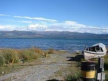
Driving in the yukon near kluane lake alaska highway
Kluane Lake is located in the southwest area of the Yukon. It is the largest lake contained entirely within Yukon at approximately 408 km2 (158 sq mi), and 81 km (50 mi) long.
Contents
- Driving in the yukon near kluane lake alaska highway
- Map of Kluane Lake Yukon Canada
- Kluane lake yukon sept 2011
- Communities
- Northern Mountain Caribou
- References
Map of Kluane Lake, Yukon, Canada
Until 2016, Kluane Lake was fed by the A'ay Chu (Slims River), which was composed of meltwater from the Kaskawulsh Glacier, located within Kluane National Park. It drains into the Kluane River, whose waters flow into the Donjek River, White River, Yukon River, and eventually the Bering Sea. The lake has a high density of large-bodied lake trout and whitefish and is known for its fishing.
Kluane Lake is located approximately 60 km (37 mi) northwest of Haines Junction. The lake has a mean depth of 31 m (102 ft) and a maximum depth of 91 m (299 ft)
The Alaska Highway follows most of Kluane Lake's southern border, and the drive offers many spectacular views of the lake.
Kluane lake yukon sept 2011
Communities
The Yukon communities of Burwash Landing and Destruction Bay are located on the southern shore of the lake.
Northern Mountain Caribou
The Aishihik and Kluane caribou herds migrate in the area surrounding Kluane and Aishihik Lakes. They are a northern mountain caribou, a distinct ecotype of the woodland caribou. In 2009 there were 181 caribou in the Kluane herd (also known as the Burwash herd) and 2044 caribou in the Aishihik herd. The Kluane herd was declining while the Aishihik herd was increasing.