
 | ||
Similar Donjek Glacier, Mount Logan, Mount Kennedy, Bagley Icefield, Mount Vancouver | ||
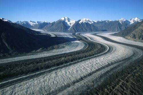
The Kaskawulsh Glacier is a vast, temperate valley glacier nestled in the St. Elias Mountains, within Kluane National Park in the Canadian territory of Yukon. Located approximately 6000–9000 ft (2000–3000 m) above sea level, the glacier covers more than 15,000 mi2 (25,000 km2) of the surrounding landscape. It terminates at the head of two river valleys, the Slims and the Kaskawulsh River, which feed the Yukon River (via Kluane Lake) and Alsek River systems respectively. The Kaskawulsh is the result of two converging outlet glaciers, the Central and North Arms, and is an impressive 3-4 mi (5–6 km) wide at its broadest point.
Map of Kaskawulsh Glacier, Yukon, Unorganized, Yukon, Canada
Backpackers can visit the Kaskawulsh along the popular Slims River West Trail, which follows the Slims River south for 19.9 mi (31.9 km) before ending at the summit of Observation Mountain near the toe of the glacier.