
Population 758 (2011) Civil parish Kirkby Thore Local time Tuesday 5:58 PM | OS grid reference NY639257 Sovereign state United Kingdom Dialling code 017683 | |
 | ||
Weather 11°C, Wind W at 32 km/h, 69% Humidity | ||
Kirkby Thore is a small village, civil parish and hill in Cumbria, England at grid reference NY639257. It is close to the Lake District national park and the Cumbrian Pennines. The market town of Appleby-in-Westmorland is about 5 miles away, and the larger town of Penrith is about 8 miles away. As this suggests, it is in the historic county of Westmorland.
Contents
Map of Kirkby Thore, Penrith, UK
History
The place-name 'Kirkby Thore' is first attested in 1179 in the 'Register of Holm Cultram', where it appears as Kirkebythore. Kirkby means 'church village' or 'village with a church', whilst Thore is an Old Norse personal name related to the god Thor.
The village is on the site of a Roman cavalry camp called Bravoniacum or Brovonacae and Roman coins, tombstones, sandals, urns, earthen vessels, and the cusp of a spear have been found in the locality. The Maiden Way Roman road led north from Bravoniacum to Epiacum (Whitley Castle), and thence to Magnae (Carvoran) on Hadrian's Wall, where it joined the Stanegate road running from west to east. A continuation from there ran east to Banna (Birdoswald) and then 7 mi (11 km) north to the Shrine of Cocidius (Bewcastle). LIDAR technology has recently revealed another Roman road running southwest from Kirkby Thore to the Roman fort at Low Borrowbridge near Tebay.
The Anglican church of St Michael in Kirkby Thore is built of red sandstone and dates from Norman times. The village also has a Methodist chapel.
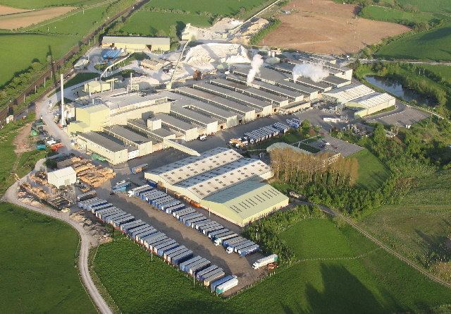
Gypsum has been quarried or mined in the area for over 200 years. The local British Gypsum Ltd plant has produced plaster since 1910 and plasterboard since the 1960s. Currently it is more economic to transport gypsum by rail from Drax Power Station than to mine it locally. British Gypsum has a private siding on the Settle-Carlisle Railway which passes to the north of the village.
Governance
An electoral ward of the same name exists. This ward stretches west to Mallerstang with a total population of 1,563.
Transport and facilities
The busy A66 road runs through the western edge of the village. This will be one of the last sections of the A66 to be upgraded to dual carriageway; in 2006 the Highways Agency conducted public consultation on the route for a bypass (which will connect the existing Appleby bypass to the east and the Temple Sowerby bypass (opened in part October 2007, ahead of schedule) to the west. The public consultation fell by the wayside and dualling of the A66 at Kirkby Thore is still an aspiration.
The village contains a village shop with post office, a BP filling station (and shop) and a Bistro serving meals.
Notable people
Siblings Helen Skelton and Gavin Skelton grew up in a farm near the village and attended Kirkby Thore Primary School before transferring to Appleby Grammar School. Helen is now a television presenter, best known for working on Blue Peter and Countryfile, whilst Gavin is a professional footballer who has played in the Scottish Premier League with Gretna, Kilmarnock and Hamilton Academicals. In 2016 he was made player-manager of Queen of the South in Dumfries.