
Sovereign state United Kingdom Postcode district TN17 Local time Monday 10:02 PM | ||
 | ||
Weather 7°C, Wind SW at 6 km/h, 85% Humidity District Borough of Tunbridge Wells | ||
Kilndown community choir in tunbridge wells 2015
Kilndown is a hamlet 5 miles (8 km) west of Cranbrook in Kent, England. At the 2011 Census the population was included in the civil parish of Goudhurst.
Contents
- Kilndown community choir in tunbridge wells 2015
- Map of Kilndown UK
- Kilndown community choir summertime 1st part 27 february 2016
- History
- References
Map of Kilndown, UK
Kilndown community choir summertime 1st part 27 february 2016
History
Kilndown was established in the 1840s by Viscount Beresford.
William Carr Beresford, First Viscount Beresford, British general and politician, died here on 8 January 1856 at age 85.
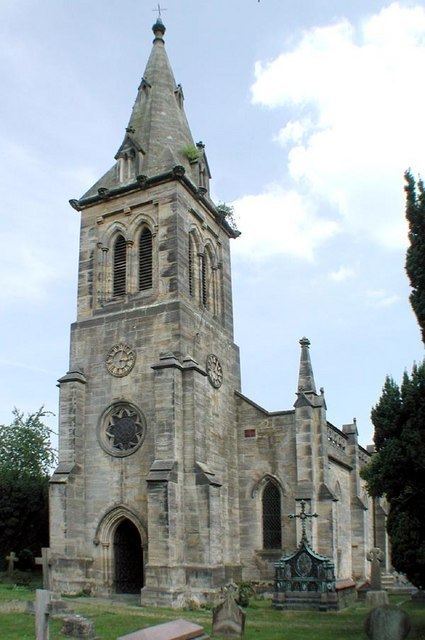
Christ Church, Kilndown was built in 1841. It is built in a unique Gothic revival style.
Kilndown first appears on Hasted's map in 1778 but was referenced as "Killdown"; the "Kiln" in the current name may have come from the kiln oasts harvested in the area, or that the area produced bricks.
Two estates existed near the village: the first was the Combwell Estate that was formed during the reign of King Henry II, however it became a priory in 1220. However the priory was destroyed during the Reformation of the Church in the 16th century. Nothing of the building remains.
The Bedgebury Estate was mentioned in a 814 charter and was a known home to the Culpeper family in the 16th century and the estate contained two Iron Furnaces to help defeat the Spanish Armada in 1588. William Carr Beresford, or Viscount Beresford, purchased the estate in 1834. This led to development on the estate and Christ Church was built. This led to numerous shops, craftsmen and a public house, which still remains today: The Globe and Rainbow.