
Country India Area 9 km2 District Nuapada | Language spoken Oriya State | |
 | ||
Map of Khariar
Khariar (also called Khadial or Kharhial) is a City and a notified area committee in Nuapada district Khariar Is a Big City In "'Nuapada district"' in the Indian state of Odisha. O
Contents
- Map of Khariar
- Economy
- Geography
- Demographics
- Areas of Khariar
- Education
- Schools
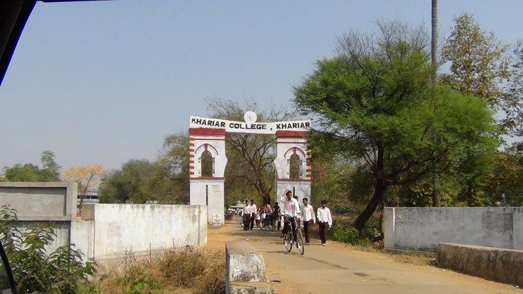
- Graduation Colleges
- Technical CollegesInstitutions
- Medical facilities
- Transportation
- Nearest Town
- Religious places
- Market
- Tourist spots
- Culture
- Festivals
- References
Economy
Nuapada district in the State of Odisha is in the western part of odisha in India and Khariar is located in the heart of Nuapada district. It comes under a rain shadow belt . Khariar is the one of the major towns in Nuapada district. It is the main business centre in the locality. It has a daily market and a weekly baazar takes place every Friday. Most people of Khariar are middle-class, which includes government employees, small shopkeepers, businessmen etc.
Geography
Khariar is located at 20.28°N 82.77°E / 20.28; 82.77. It has an average elevation of 226 m (741 ft). It is located in the Western part of Odisha, close to the border of Raipur District Chhattisgarh State. It belongs to the Mahanadi basin the Eastern Ghats where mountains are interspersed with wide valleys. The elevation is about 200 meters. The climate is tropical with the rainfall is due to the South West monsoon, There are few government and private schools and colleges in the region. Oriya is the official language of the people. Furthermore, the region is well connected with roads to many town and also railways to other part of the state. The nearest airport located is Raipur in Chhattisgarh.The Indian writers like Jitamitra Prasad Singh Deo and Avinash Patra are from Khariar region.
Demographics
As of 2001 India census. Khariar had a population of 25778. Males constitute 51% of the population and females 49%. Khariar has an average literacy rate of 62%, higher than the national average of 59.5%: male literacy is 72%, and female literacy is 52%. In Khariar, 13% of the population is under 6 years of age.
Areas of Khariar
- Deepak Kumar Behera
- Raja Pada
- Nina Pada
- Lalsaheb Pada
- Dhuba Pada
- Pattnaik Pada
- Sahu Pada
- Pathan Pada
- Ada Pada
- Bangti Pada
- Braman Pada
- Sabar Pada
- Putu Pada
- Gousala Pada
- Chelia Pada
- Police Pada
- Satnami Pada
- Phokat Pada
- Bijepur Pada
- Chatria Pada
- Parua Pada
- Muktapur
- Santi Nagar
- Meher colony
- Laxmi Nagar
- Indra Nagar
- Maruti Nagar
- Sri Krushna Nagar
- SriRam Nagar
- Satyabadi Nagar
- Vidya nagar
- Padmasri Nagar
- Gadramunda Pada
- Padampur Pada
- Badi
- Chalanpada
- Luhurapali
- Kotipadar
- irrigation colony
City area of KHARIAR includes nearby sub-urban areas like Padmapur, Badi, Junani, Chindaguda, Chalanpada
Education
Khariar has one of the highest school densities in Nuapada District. Many students from Khariar has gone outside to pursue their study.The best Odia Midume school is Saraswati sishu vidya mandir. And the Best Student of S.S.V.M Khariar of the Year 2017 is Sohan Nayak Class 10th. the Best English Midumeschool is Khariar Public School.And the Best Student of K.P.S is Kunal Agrawal.
Schools
For higher studies also Khariar has some colleges in the region.
Graduation Colleges
Technical Colleges/Institutions
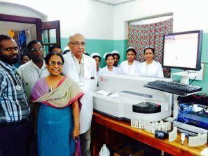
Medical facilities
Transportation
Khariar is a major transportation hub in Nuapada District as people from the three blocks namely Boden, Sinapali and Khariar depend upon the mode of transportation available in Khariar. Though Khariar is not connected by rail, it is well connected by roads. The major roads passing through Khariar are NH 353, SH 16 etc. The nearest rail head is Kantabanji, which is situated 35 km from Khariar. Another nearest railway station is Titlagarh (which is also the hottest place in India. The nearest airport is Raipur Airport situated 195 km from Khariar.
Nearest Town
- Katabanji 30 km
- Komna 26 km
- Titlagarh 46 Km
- Sinapali 30 Km
- Bolangir 110 km
- Bhabanipatna 70 km
- Nuapada 65 km
- Khariar Road 75 km
- Raipur 190 km
- Sambalpur 240 km
- Bhubaneswar 430 km
Religious places
There are several religious places of different religion in Khariar, this indicates a diversity in religion, culture in Khariar. Some of the temples located in Khariar are:-
Some of the other religious places of other communities are:-
Market
Tourist spots
There are several tourist spots around Khariar. Some of them are listed below:-
chindaguda shiv mandir (Baidehiswar )
Culture
Khariar's culture is a blend of traditional festivals, food, dance etc. Khariar offers a cosmopolitan and diverse lifestyle with a variety of food, entertainment and standard of living. Khariar has a proud cultural heritage that arose due to intermingling of different religions. The major language used is Odia, which is widely used in each and every part of Khariar region. English is widely used for official purpose. Nuakhai is the major festival celebrated in this region. The other festivals like rathayatra, dusshera, holi, dipawali, eid, Christmas, chindaguda (Dhanujatra Mahotsav, Anchalika Sanskrutik Utsav , (Chindaguda ) are also celebrated in Khariar. Khariar organises Khariar Mahotsav every year, which attracts a large number of people from different places.
Khariar is basically one of the peaceful town in Odisha . The town remains active from 8AM to 9:30PM usually. The activities of this town includes:- running of schools,Shops or very small industries and bus communications. Other then these activities political activities across the town is also common. In evening, it is a common site to see youth playing at various fields (mostly at RAJA A.T. HIGH SCHOOL field, Vidya Mandir field, Bhojpur Field, College Field, Shanti Nagar Field). In fact the veterans also participate in several fitness activities during evening (like jogging near Canal Road, Padampur Road, Tukla Road, Nehena Road, College Road).