
PIN 754 xxx Area 2,644 km² Population 1.44 million (2011) | Time zone IST (UTC+5:30) Vehicle registration OD-29 Literacy 77.3% | |
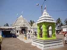 | ||
Points of interest Bhitarkanika National Park, Gahirmatha Beach, Sri Lakshmi Varaha S | ||
Bhitarkanika sanctuary kendrapara district orissa india photo slide
Kendrapara District is an administrative district of Odisha state in eastern India. The town of Kendrapara is the district headquarters. Kendrapara District is situated in the eastern portion of the state, and is bounded on the north by Bhadrak District, on the east by the Bay of Bengal, on the south by Jagatsinghpur District, on the west by Cuttack District and on the northwest by Jajpur District.
Contents
- Bhitarkanika sanctuary kendrapara district orissa india photo slide
- Map of Kendrapara Odisha
- Geography
- Divisions
- Demographics
- Tourism
- Vidhan sabha constituencies
- References
Map of Kendrapara, Odisha
Geography
Kendrapara District lies in 20° 20’ N To 20° 37’ N Latitude and 86° 14’ E To 87° 01’ E Longitude and situated in central coastal plain zone of the Odisha. The Bay of Bengal lies in the eastern part of the district. The coastline covers 48 km stretching from Dhamra Muhan to Batighar. Kendrapara district headquarters is 85 km from the State headquarters.
Kendrapara District lies in the river delta formed by the Brahmani and Baitarani & branch rivers of Mahanadi. The Bhitarkanika Mangroves, Bhitarkanika National Park, Gahirmatha Beach & Baladevjew Temple lie in the district. The district has also other beautiful places like Suka-Parikshita Ashram, Kudanagari,Pentha sea beach, Harihar Kshetra Mahala, Gadadhara Gosain Pitha, Korua etc. This district has 9 blocks named as Aul, Derabish, Garadpur, Mahakalapada, Marshaghai, Kendrapara, Rajanagar, Rajkanika, Patamundai.
Divisions
There are 9 Tahasilsand 9 blocks in Kendrapara district. They are :
Tahasils
- aul
- Kanika
- Kendrapara
- Marshaghai
- Pattamundai
- Rajnagar
- Mahakalpada
- Derabish
- Garadpur
Blocks
- Aul
- Derabis
- Garadpur
- Kendrapara
- Mahakalpada
- Marshaghai
- Patamundai
- Rajakanika
- Rajnagar
Demographics
According to the 2011 census Kendrapara district has a population of 1,439,891, roughly equal to the nation of Swaziland or the US state of Hawaii. This gives it a ranking of 344th in India (out of a total of 640). The district has a population density of 545 inhabitants per square kilometre (1,410/sq mi) . Its population growth rate over the decade 2001-2011 was 10.59%. Kendrapara has a sex ratio of 1006 females for every 1000 males, and a literacy rate of 85.93%. The mother tongue of most of the people here is Odia; there is a sizable number of Bengali and Urdu speaking people. Hindi is also widely understood.
Tourism
There are several tourist places in Kendrapara. Batighara is the first lighthouse installed in eastern coast of India. It is surrounded with pleasant natural beauty. In front of the Batighar, False Point Port was the first modern port of the Odisha coast. This port was commissioned in the year 1855. Kanika Palace is one of the most popular tourist places in Kendrapara District. It is situated in Rajkanika block and around 50 km from Kendrapara. The beauty of the palace is unbelievable. Aul Palace is another tourist site and it is an ancient palace spread over 40 acres of land. Other structures like Rajbati, Ranimahal, Ghodashala, Bhandar, Udyan, Pramoda Udyan, Debalaya, Devi mandir are included in the palace. Dhamara Port is an ancient port on the bank of river Baitarani, around 5 km from Kanika Palace. Kudanagari is an ancient center of maritime business, which is situated in Patkura constituency. A massive sand dune sprawling over 15 acres of land and of a height 25 feet, surrounded by deep forest is a popular pilgrim center. All the places of interest of Kendrapara District are worth visiting. The district is known for its Temples, Fairs and Wildlife Sanctuaries. Notable tourist places are
Vidhan sabha constituencies
The following is the 5 Vidhan sabha constituencies of Kendrapara district and the elected members of that area