
Progression Southwest-northeast Discharge 600 m³/s | Length 410 km Basin area 19,000 km² | |
 | ||
Main source Selwyn Mountains1,401 m (4,596 ft) River mouth Mackenzie River121 m (397 ft) Basin size 19,000 km (7,300 sq mi) Tributaries Left:Tsichu River, Intga River, Ekwi River, Twitya River, Summit CreekRight:Sekwi Brook, Natla River, Dorkan Creek, Nidhe Brook, Naintin Brook, Toochingkla River, Moose Nest Creek, Red Dog Creek, Middle Creek | ||
The Keele River is a tributary of the Mackenzie River, about 410 kilometres (250 mi) long, in the western part of the Canadian Northwest Territories. Flowing in a generally northeast direction, it drains a sparsely populated, rugged area of the Mackenzie Mountains.
Contents
Map of Keele River, Northwest Territories, Canada
Course
The Keele River originates in a small, unnamed lake near the border of the Northwest Territories and the Yukon, approximately 25 kilometres (16 mi) south of Macmillan Pass, which is the terminus of the drivable section of the North CANOL Road. The river begins its journey by flowing northwest through the alpine tundra area known as the Mackenzie Mountain Barrens, joining the Tsichu and Intga Rivers along the way. It then drops off the alpine plateau and begins its long descent to the Mackenzie River, tumbling gradually down into the dramatic Backbone Ranges of the Mackenzie Mountains. Approximately 100 kilometres (62 mi) from the Keele's source, the Natla River rushes into the Keele from the south and almost doubles the flow and size of the river. From the Natla Confluence, The Keele turns and snakes its way northward for 85 kilometres (53 mi) until it meets the Twitya River, its largest tributary, flowing in from the west. Just after the Twitya confluence, the Keele is deflected east around the Tigonankweine Range by the towering Mount Eduni Massif and continues in this direction until reaching the Mackenzie River. During this section, the Toochingkla River flows in from the south, before the Keele cuts between the spectacular Canyon and Redstone Ranges. It then leaves the mountains behind, becoming slow and braided, and receives Middle Creek from the south, merging into the Mackenzie some 13 kilometres (8.1 mi) downstream from the Redstone River and 50 kilometres (31 mi) south-southeast of Tulita.
History
People have inhabited the area surrounding the Keele River for at least 11,000 years. The river was originally a path for some tribes of the Mountain Dene people to travel from their summer hunting grounds in the Yukon to winter camps on the Mackenzie River. After hunting for moose and beaver in the mountains, the Mountain Dene or Shuhtaot'ine would trade these furs at Tulita (formerly Fort Norman), many kilometres downstream from the Keele's confluence with the Mackenzie. After signing Treaty 11 (regarding the transfer of lands in the Yukon to the federal government for purposes of oil exploration) with King George V in 1921, the Dene no longer went to the Yukon as frequently and as a result the Keele was also less travelled. The Keele also has been known as the Gravel River.
The river was named, as was the Keele Peak, for Joseph Keele, a member of the Geological Survey of Canada, who had surveyed the area in 1907–08.
Recreation
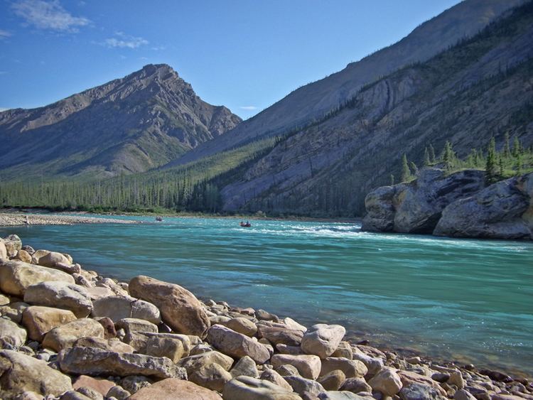
In recent years the Keele River, the less travelled little cousin of the South Nahanni River, has become known as a world class destination for wilderness canoeing and rafting, seeing hundreds of people paddle down its lower section each summer. This is due to a perfect combination of spectacular rugged mountain scenery, excellent fishing and wildlife viewing and fun but challenging class 2+ whitewater with no portages. Swift currents, rapids and glacial cold water in a wilderness setting hundreds of kilometres from the nearest road mean that this river offers a thrill and a challenge to all who paddle it. Several outfitting and guiding companies offer guided tours down the Natla/Keele river system during all months of the summer. Trips usually depart Norman Wells by floatplane and land on the river at the Natla-Keele confluence. Trip length is usually between 10 and 14 days; however, it is feasible to have a longer trip by pairing the Keele with the Natla river. (It should be noted that the Natla is a class 3-4 river, and therefore is an experts-only trip).