
Founded January 16, 1836 Area 1,357 km² | Website countyofkane.org Population 523,643 (2013) Unemployment rate 4.8% (Apr 2015) | |
 | ||
Destinations Points of interest Grand Victoria Casino El, Garfield Farm and Inn Muse, Phillips Park Zoo, Batavia Depot Museum, William Tanner House M | ||
Kane County is a county in the U.S. state of Illinois. According to the 2010 census, it has a population of 515,269, making it the fifth-most populous county in Illinois. Its county seat is Geneva, and its largest city is Aurora.
Contents
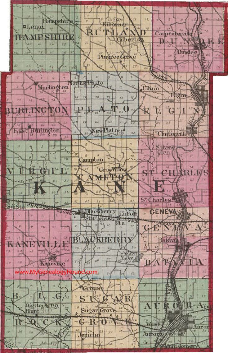
- Map of Kane County IL USA
- History
- Geography
- Climate
- Adjacent counties
- Forest preserves
- Demographics
- Education
- Health care
- Transportation
- Airport
- Major highways
- Cities
- Census designated place
- References
Map of Kane County, IL, USA
Kane County is one of the collar counties of the Chicago-Naperville-Elgin, IL-IN-WI Metropolitan Statistical Area.
History
Kane County was formed out of LaSalle County in 1836. The county was named in honor of Elias Kane, United States Senator from Illinois, and the first Secretary of State of Illinois.
Geography
According to the U.S. Census Bureau, the county's area was 524 square miles (1,360 km2), of which 520 square miles (1,300 km2) is land and 4.1 square miles (11 km2) (0.8%) is water. Its largest cities are along the Fox River.
Climate
In recent years, average temperatures in the county seat of Geneva have ranged from a low of 10 °F (−12 °C) in January to a high of 84 °F (29 °C) in July, although a record low of −26 °F (−32 °C) was recorded in January 1985 and a record high of 111 °F (44 °C) was recorded in July 1936. The average monthly precipitation ranged from 1.52 inches (39 mm) in February to 4.39 inches (112 mm) in July.
Adjacent counties
Forest preserves
Kane County has an extensive forest preserve program, with numerous nature preserves, historic sites, and trails.
Demographics
As of the 2010 United States Census, there were 515,269 people, 170,479 households, and 128,323 families residing in the county. The population density was 990.8 inhabitants per square mile (382.6/km2). There were 182,047 housing units at an average density of 350.1 per square mile (135.2/km2). The racial makeup of the county was 74.6% white, 5.7% black or African American, 3.5% Asian, 0.6% American Indian, 13.0% from other races, and 2.6% from two or more races. Those of Hispanic or Latino origin made up 30.7% of the population. In terms of ancestry, 24.3% were German, 13.0% were Irish, 7.9% were Polish, 7.4% were Italian, 7.1% were English, and 2.4% were American.
Of the 170,479 households, 42.3% had children under the age of 18 living with them, 59.2% were married couples living together, 11.0% had a female householder with no husband present, 24.7% were non-families, and 19.8% of all households were made up of individuals. The average household size was 2.98 and the average family size was 3.45. The median age was 34.5 years.
The median income for a household in the county was $67,767 and the median income for a family was $77,998. Males had a median income of $53,833 versus $39,206 for females. The per capita income for the county was $29,480. About 7.0% of families and 9.1% of the population were below the poverty line, including 13.5% of those under age 18 and 5.7% of those age 65 or over.
Education
Health care
There are several hospitals serving the county: