
Season All Length 55,522 m | Trail difficulty Easy Website Official site Trailheads Kalamazoo, South Haven | |
 | ||
Management Michigan Department of Natural Resources Similar Van Buren State Park, Kalamazoo River Valley Trail, Michigan Maritime Museum, Michigan Flywheelers Museum, Wapack Trail | ||
The Kal-Haven Trail, formally known as the Kal-Haven Trail Sesquicentennial State Park, is a rail trail that originally ran 33.5 miles (55 km) between South Haven, Michigan, to a point just west of the city of Kalamazoo, Michigan, where there is a trailhead. In 2008 the trail was extended east from the trailhead to downtown Kalamazoo as part of the Kalamazoo River Valley Trail.
Contents
Map of Kal-Haven Trail Sesquicentennial State Park, Michigan, USA
Most of the trail is in Van Buren County and that county operates it between the trailhead and South Haven, including the parts within Kalamazoo County. The Van Buren-controlled portion previously required a trail pass, but as of 2011, the usage fee was dropped.
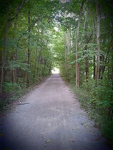
The Kal-Haven Trail runs along the former route of the Kalamazoo and South Haven Railroad, as does a section of the Kalamazoo River Valley Trail. It traverses wooded areas, farmland and small towns. It is primarily used by hikers and bicyclists in the summer, and by snowmobilers in the winter. The trail is surfaced with crushed limestone. Horseback riding is allowed on an 11-mile section adjacent to the trail. The starting point for riding is at 67th street and Baseline road.
There are two primitive campgrounds that can be used at an additional cost. One, near Gobles, has water and a toilet. The other near South Haven has a toilet but no water.
Van Buren County offered a shuttle service through Van Buren Public Transit from South Haven to Kalamazoo and can accommodate up to four bikes and their riders. As of 8/14/2015 this service was no longer offered.
Currently the trail passes through the following locations, from east to west:
The trail is owned by the state of Michigan but, due to state budget cutbacks, in 2004 operation was taken over by Van Buren County, including the portion in Kalamazoo County. A trail pass system was re-instituted to pay for trail maintenance, but was dropped again in 2011.
The Kalamazoo Trail Head to South Haven Trail Head contain major deer fly populations. You pass through small towns, one notably is Gobles, Michigan. Throughout this trail are many cautionary signs, such as Stop Sign and stop ahead.
Several miles south of the western terminus is another trail—the Van Buren Trail State Park. This is also an old railroad bed, ending in Hartford, Michigan. The trail is unimproved and the largest group of users are snowmobilers and horse and buggy riders. This is also operated by Van Buren County. The trail pass is valid for both.
For the Kalamazoo River Valley Trail, in November 2004 the State of Michigan completed a tunnel underneath the U.S. Highway 131 freeway, which was the major impediment to extending the trail to downtown Kalamazoo. The city of Kalamazoo approved a $1 million project to extend the trail southeast under U.S. 131 along Ravine Road to Westnedge Avenue in downtown Kalamazoo. Most of the extension was built along the former roadbed of the Kalamazoo and South Haven Railroad.
Waypoints
Waypoints for the Kal-Haven Trail.
↑ in the Distance column points to the other waypoint that the distance is between.