
Country United States Incoporation (village) 1893 Area 2.67 km² Zip code 49055 Local time Wednesday 6:53 PM | Platted 1870 Incoporation (city) 1957 Elevation 249 m Population 819 (2013) Area code 269 | |
 | ||
Weather -3°C, Wind NW at 23 km/h, 58% Humidity | ||
How to say or pronounce usa cities gobles michigan
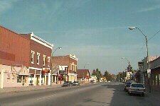
Gobles is a city in Van Buren County of the U.S. state of Michigan. As of the 2010 census, the city population was 829. It was originally called Gobleville, after its founders, the Goble family.
Contents
- How to say or pronounce usa cities gobles michigan
- Map of Gobles MI 49055 USA
- Klassic arcade and klassic sodas in gobles michigan
- History
- Geography
- 2010 census
- 2000 census
- Attractions
- References
Map of Gobles, MI 49055, USA
Klassic arcade and klassic sodas in gobles michigan
History
1n 1864-1865, John Goble built a hotel at this location. In 1870, a plat was laid out as Gobleville by Hiram E. Goble. Warren Goble platted an addition to the original plat two years later. Hiram Goble also became the first postmaster on April 16, 1872 when the post office was moved from Lake Mills. Gobleville was incorporated as a village in 1893. The current name of Gobles was adopted on April 10, 1922. Gobles was incorporated as a city in 1957.
On April 6, 2012, a fire raged throughout downtown in which six fire departments were called in. The various buildings that were destroyed were over 100 years old.
Geography
According to the United States Census Bureau, the city has a total area of 1.03 square miles (2.67 km2), all land.
2010 census
As of the census of 2010, there were 829 people, 320 households, and 210 families residing in the city. The population density was 804.9 inhabitants per square mile (310.8/km2). There were 347 housing units at an average density of 336.9 per square mile (130.1/km2). The racial makeup of the city was 93.1% White, 0.6% African American, 0.2% Native American, 1.7% from other races, and 4.3% from two or more races. Hispanic or Latino of any race were 4.9% of the population.
There were 320 households of which 35.3% had children under the age of 18 living with them, 45.3% were married couples living together, 14.1% had a female householder with no husband present, 6.3% had a male householder with no wife present, and 34.4% were non-families. 29.7% of all households were made up of individuals and 15% had someone living alone who was 65 years of age or older. The average household size was 2.59 and the average family size was 3.24.
The median age in the city was 37.7 years. 27.6% of residents were under the age of 18; 6.9% were between the ages of 18 and 24; 26% were from 25 to 44; 26.7% were from 45 to 64; and 12.7% were 65 years of age or older. The gender makeup of the city was 47.6% male and 52.4% female.
2000 census
As of the census of 2000, there were 815 people, 314 households, and 209 families residing in the city. The population density was 786.9 per square mile (302.6/km²). There were 333 housing units at an average density of 321.5 per square mile (123.6/km²). The racial makeup of the city was 94.11% White, 1.84% Native American, 0.12% Asian, 1.10% from other races, and 2.82% from two or more races. Hispanic or Latino of any race were 2.33% of the population.
There were 314 households out of which 35.0% had children under the age of 18 living with them, 44.9% were married couples living together, 16.9% had a female householder with no husband present, and 33.4% were non-families. 28.7% of all households were made up of individuals and 15.0% had someone living alone who was 65 years of age or older. The average household size was 2.57 and the average family size was 3.13.
In the city, the population was spread out with 30.6% under the age of 18, 8.2% from 18 to 24, 29.2% from 25 to 44, 18.8% from 45 to 64, and 13.3% who were 65 years of age or older. The median age was 34 years. For every 100 females there were 81.9 males. For every 100 females age 18 and over, there were 76.3 males.
The median income for a household in the city was $26,917, and the median income for a family was $33,194. Males had a median income of $31,250 versus $21,818 for females. The per capita income for the city was $12,804. About 16.4% of families and 18.3% of the population were below the poverty line, including 21.0% of those under age 18 and 17.8% of those age 65 or over.
Attractions
The popular Kal-Haven Trail, which runs from Kalamazoo to South Haven, Michigan, goes through the city's business district. Gobles is also home to Timber Ridge Ski Area.