
Palestine grid 154/173 | ||
 | ||
Name meaning "The ruin of the village of the third part" Weather 15°C, Wind N at 8 km/h, 66% Humidity | ||
Kafr Thulth (Arabic: كفر ثلث) is a Palestinian town located on high, flat land south of Azzoun, 28 kilometers (17 mi) south of Tulkarm in the Qalqilya Governorate. The average elevation is 270 meters (890 ft) above sea level. According to the Palestinian Central Bureau of Statistics, the town's population was 3,921 in the 2007 census.
Contents
- Map of Kafr Thulth
- Name
- Geography
- Archeology
- History and occupation
- Agriculture
- Services
- Industry
- Education
- References
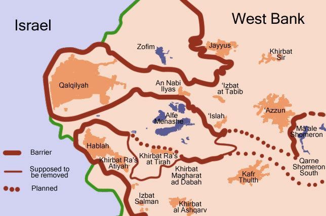
Map of Kafr Thulth
Name
Kafr in arabic means "village" and Thulth means "three" or "a third". This Arabic name preserves the place name of Baal-shalisha, an ancient village believed to have been located 3.5 miles (5.6 km) to the south at a site known in modern times as Khirbat Sirisya.
Geography
Kafr Thulth is bordered by Azzun to the south, Sanniriya and Biddya villages to the east and Deir Istiya to the west. In 1948, parts of Kharab and Aizab, such as, Salman, al-Moudwer, al-Sheikh Ahmad, al-Ashqar, Ras Tirah, al-Dabha, Kirash Kherba and Ras Atiya — villages or land areas that originally belonged to Kafr Thulth were separated from the town by the Green Line, which forms the border between Israel and the West Bank.
Kafr Thulth's land was extended to the border of the Auja stream and by the 19th century the town's total land area was about 50-60,000 dunams. It had bordered Habla, Jaljuliya, Azzun and Islah, but Kafr Thulth's jurisdiction decreased in 1954; Then, the distance was 924 dunams, while the distance reached up to Kherash Kherba that belong to Kafr Thulth 3,665 dunams.
Archeology
There are several ruins or khirbets in Kafr Thulth:
History and occupation
In 1517, the village was incorporated into the Ottoman Empire with the rest of Palestine, and in 1596, Kafr Tult appeared in Ottoman tax registers as being in nahiya (subdistrict) of Jabal Qubal under the liwa' (district) of Nablus. It had a population of 13 households and 1 batchelor, all Muslims. They paid taxes on wheat, barley, summer crops, occasional revenues, goats and/or beehives. In 1835, Kafr Thulth was included in a village list drawn up by Edward Robinson, part of Jurat Merda, south of Nablus.
In 1852, Robinson described Kafr Thulth as "a ruin", and the same did Victor Guérin in 1870. However, later researchers have noted that both only saw Kafr Thulth from a distance, and might have had it mixed up with the ruin Kufr Qara.
In 1882 the Palestine Exploration Fund's Survey of Western Palestine described the village (called Khurbet Kefr Thilth) as "a small village on high ground, with two wells. It was in ruins in 1852, but has now a few inhabitants, the ground round is rough and uncultivated."
In the 1922 census of Palestine conducted by the British Mandate authorities, Kufr Thelth had a population of 643, all Muslims, while in the 1931 census Kafr Thulth, (including Khirbat Khris), had 169 occupied houses and a population of 955, still all Muslim.
Agriculture
The people of this town work hard to get use of land and plant olive trees the use local workers, and machinal, the land distance increased from 1000 donoms, in 1945 to 18000 donoms, in 2004 before the citizens were working with their neighbors in olive the income of a family reached up to 500 kg of olive oil, in addition of planting vegetables and Blastic houses, in addition of cultivating their lands different kinds of trees, Kafr Thulth is considered the second town in Palestine dealing with the distance of its land, about 2600 donoms, a lot of lands were lost because of occupations, like Turkish, British mandate, most of its people worked in Israeli settlements, the other worked in commercial back to Jordanian Authority on Palestine, they work in cultivation, as farmers, and digging wells of water, and there are eight wells, in salman village, Al-Moudawar and Alsheilk Ahmad.
This town considered as one of towns that plant olive trees and producing a lot of olive oil. So there are three places for squeezing olive fruit in order to get oil out of it. One of these projects is out of service because of having a misunderstanding between the partner, in general the most important problem that the town suffer from is water and this was reflected on planting and cultivating more, and concentrating on well water for irrigation.
Most of people in Kafr Thulth like to breed different kinds of animals and birds like sheep. Goats, doves, chickens, hens, to reinforce the idea of self autonomy, and number of sheep reached up to 10,000 head, besides 40,000 birds in 1998 but these numbers were decreased because of establishing "apartheid wall campaign" which cover a distance of 7000 donoms of land that belong to Kafr Thulth.
Services
General services in Kafr Thulth people are Economical Activity: Kafr Thulth people are very active in all fields "agricultural, educational and commercial" they work very hard, man, woman, worked together to keep live.
Kafr Thulth has many establishments formal and local and these give services to people, like : Local Council : Mayer's worked for a long time in delivering services to people, in Jordanian period and British one, from 1958–1994, this period ended when our Palestinian Authority came in to Palestine and Kafr Thulth became a municipality, because of increasing of people and citizens, and this municipality is run by a chief and twelve members covering all period because of the political reasons from 1966-1974 they establish a clinic, and a public telephone, building more rooms and halls and transfer of school level –from primary to elementary- establishing a school especially for girls in 1972. In period expanded from 1974–1994, many rooms were established, repairing streets and roads, and establishing electrical project by buying electrical motors, fits the needs of the town and establishing Kufur Thuluth charitable society, while period extended from 1995-1997 adding more rooms schools and repairing Al-Ashkar road in cooperation with other establishment, two primary schools were built so far, for girls and boys they spend many efforts to bring in water for Kafr Thulth, but Israeli objected that.
Industry
The industrial sector is very simple and primary one, because of the shortage of the mair resources this sector needs, like electricity isn't enough to over come this problem, while in the last period a wide development was achieved by providing the town with electric – motors – In our town there are four sewing shops, and two metal workshops in addition to mechanic and flat tires workshops.
Education
There are four schools in town, including males and females (girls & boys) and cover different levels of education. The importance of Kafr Thulth secondary school is obvious because other surrounded villages joined in this school, in spite of having schools in place.