
Palestine grid 163/180 | ||
 | ||
Name meaning "The village of Kaddum" Weather 14°C, Wind N at 11 km/h, 66% Humidity | ||
Kafr Qaddum (Arabic: كفر قدّوم) is a Palestinian town in the northern West Bank, located 13 kilometers west of Nablus and 17 kilometers east of Qalqilya in the Qalqilya Governorate. Surrounding towns include Jit to the east and Hajjah to the south. According to the Palestinian Central Bureau of Statistics (PCBS), the town had a population of approximately 3,500 inhabitants in mid-year 2006.
Contents
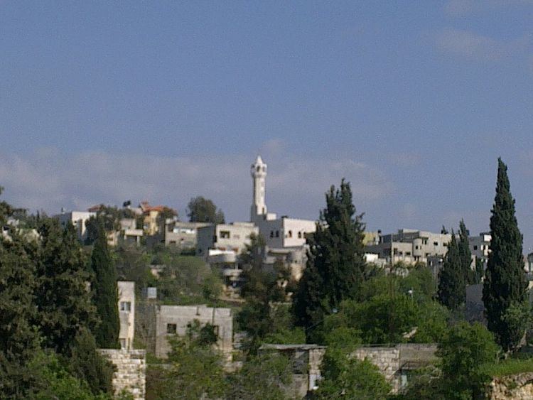
- Map of Kfar Kadum
- Ottoman era
- British Mandate period
- 1948 1967
- 1967 present
- Land issues
- Main entrance
- Events
- References
Map of Kfar Kadum
Kafr Qaddum's total land area consists of nearly 19,000 dunams (about 8,000 under Palestinian civil administration and 11,000 under complete Israeli control). Its built-up area consists of 529 dunams. Olive groves make up 80% of the remaining land, 15% is used for vegetation purposes, and 5% are planted crops.
Prior to the Second Intifada, about 50% of the Kafr Qaddum's economy depended on work in Israel as the primary source of income, 20% depended on agriculture and animal raising, while 30% depended on jobs in private and public sectors. After 2002, over 75% of the population became jobless as business became the only other alternative for income generation. Emigration has registered a record level during the past two years, ranging between 10-15% of the total population.
Since 2003, the road between Kafr Qaddum and Nablus is blocked thus elongating the travel distance by 14 km. Since July 2011, weekly demonstrations have been held in a demand to re-open the road.
Ottoman era
Kafr Qaddum appeared in 1596 Ottoman tax registers as being in the Nahiya of Jabal Qubal of the Liwa of Nablus. It had a population of 19 households and 2 bachelors, all Muslim. The villagers paid taxes on wheat, barley, summercrops, olives, and goats or beehives, and a press for olives or grapes.
In 1858, it was by noted Biblical scholar Edward Robinson on his travels in the region, and in 1882 the Palestine Exploration Fund's Survey of Western Palestine the village (called Kefr Kaddum) was described as "A good-sized village on low ground, with wells and olives; it has a watch-tower on the side of the chalk hill rising over it on the east, and is supplied by wells; the houses are of stone."
British Mandate period
In a 1922 census of Palestine conducted by the British Mandate authorities, Kufr Qaddum had a population of 874 inhabitants, all Muslims, increasing in the 1931 census, when Kafr Qaddum had 234 occupied houses and a population of 963, again all Muslim.
In 1945 the population was 1,240, all Muslims, with 18,931 dunams of land, according to an official land and population survey. Of this, 2,945 dunams were for plantations or irrigated land, 7,184 for cereals, while 69 dunams were built-up land.
1948-1967
In the wake of the 1948 Arab–Israeli War, and after the 1949 Armistice Agreements, Kafr Qaddum came under Jordanian rule.
1967-present
After the Six-Day War in 1967, Kafr Qaddum has been under Israeli occupation.
Land issues
In the Mitzpe Yishai neighborhood of the illegal Israeli settlement Kedumim, there are issues that the Israelis have improperly taken control of private Palestinian land. The Israeli Civil Administration calls it "theft", though it occurred in an "orderly manner", but without any official authorization.
Main entrance
In 2003, the Israeli military closed the main entrance of the village that connects it to Nablus with a permanent roadblock, in addition, a dirt mound was put one kilometer before the roadblock, isolating one family house which made it unreachable by vehicles. In 2010, after waiting for five years for an Israeli court decision, it was ruled that the roadblock is illegal, but the court also stated that the road is "too dangerous to travel" so the Israeli forces used it as an excuse to keep it blocked.
The roadblock makes it difficult for people to reach their farmlands because they are prohibited from driving, so they must walk on foot and carry their equipment and harvest. It also delays the fifteen minute journey to Nablus to forty minutes.