
Parent range Santa Lucia Mountains Easiest route Trail Prominence 1,355 m | Topo map Junipero Serra Peak Elevation 1,785 m | |
 | ||
Listing North America isolated peaks 97thCalifornia county high points 36th Similar Ventana Double Cone, San Benito Mountain, Mount Linn, Granite Peak, Mount Pinchot | ||
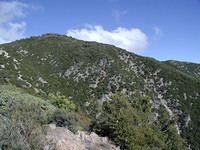
Junipero Serra Peak is the highest mountain in the Santa Lucia Mountains of California. It is also the highest peak in Monterey County. It is named after Franciscan Friar Junípero Serra, founder of the California Missions.
Contents
Map of Junipero Serra Peak, California 93927, USA
ToponymyEdit
It was originally named Santa Lucia Peak, as it is the highest point in the range of the same name. Wanting to honor Junípero Serra, the Native Daughters of the Golden West had bestowed his name upon a Sierra Nevada peak in June 1905. However, the Sierra Club recommended that the name be transferred to Santa Lucia Peak. The United States Board on Geographic Names officially approved the name change in 1906 finding that Junípero Serra was familiar with the Santa Lucia Mountains, but in all likelihood he had never encountered the Sierra Nevada.
The peak is also sometimes called Pimkolam, its ancient Salinan Native American name.
ClimateEdit
Since the peak is over 5,000 feet (1,500 m), temperatures in winter are low enough to support snowfall and relatively high amounts of precipitation compared to the Salinas Valley and places farther east in the Coast Ranges.
Indians FireEdit
Along with much of the southern Ventana Wilderness, Junipero Serra was burned extensively in the 2008 Indians fire.