
Built 1967–1968 Surface elevation 1,451 m Mean depth 4.9 m Shore length 4.2 km | Primary outflows Motett Creek Surface area 92.33 acres (37.36 ha) Area 37 ha Catchment area 10.88 km² | |
 | ||
Primary inflows Managing agency United States Forest Service | ||
Jubilee lake oregon trout fishing
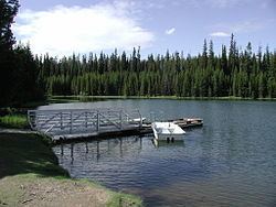
Jubilee Lake is a 92.33-acre (37.36 ha) man-made lake in the Umatilla National Forest in the northern corner of Union County in the U.S. state of Oregon. It is located 19 miles (31 km) north of Elgin and about 11 miles (18 km) south of the Washington border, at an elevation of 4,761 feet (1,451 m). Its basin spans Union, Umatilla, and Wallowa counties. The lake was made for recreation in 1968 when an earthen dam, 350 feet (110 m) long and 50 feet (15 m) high, was constructed on Motett Creek. A U.S. Forest Service campground at the lake has 53 sites and is the most heavily used campground in the Umatilla National Forest. Fishing and swimming are the most popular activities at the lake. A 2.8-mile (4.5 km) trail around the shore was designated a National Recreation Trail in 1981.
Contents
Map of Jubilee Lake, Oregon, USA
Jubilee Lake is considered mesotrophic, with an intermediate level of biological activity, and its drainage basin receives about 50 inches (1,300 mm) of precipitation annually. Rainbow trout are stocked in the lake for anglers, and youth fishing event is held at the lake each year.