
- elevation 6,681 ft (2,036 m) - average 2,075 cu ft/s (59 m/s) Length 457 km | - elevation 268 ft (82 m) Basin area 20,720 km² Discharge 58.28 m³/s | |
 | ||
Cities Mount Vernon, John Day, Prairie City | ||
Eastern oregon ranch for sale the john day river ranch
The John Day River is a tributary of the Columbia River, approximately 284 miles (457 km) long, in northeastern Oregon in the United States. Undammed along its entire length, the river is the third longest free-flowing river in the contiguous United States. There is extensive use of its waters for irrigation. Its course furnishes habitat for diverse species, including wild steelhead and Chinook salmon runs. However, the steelhead populations are under federal Endangered Species Act (ESA) protections, and the Chinook salmon have been proposed for such protection.
Contents
- Eastern oregon ranch for sale the john day river ranch
- Map of John Day River Oregon USA
- Middle fork john day river wild salmon habitat restoration
- Drainage basinEdit
- Recreation and ecosystemEdit
- Works citedEdit
- References
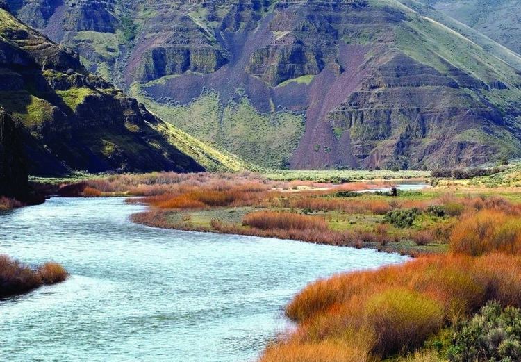
Map of John Day River, Oregon, USA
The river was named for John Day, a member of the Pacific Fur Company's overland expedition to the mouth of the Columbia River that left Missouri in 1810. Day struggled through eastern Oregon during the winter of 1811–12. While descending the Columbia River in April 1812, he and Ramsay Crooks were robbed and stripped naked by Native Americans at the mouth of the river that now bears his name, forcing them to hike 80 miles (130 km) back to friendly Umatilla Indians under extreme conditions.
The absence of dams on the river causes its flow to greatly fluctuate throughout the year depending on snowpack and rainfall within the watershed. The highest flow recorded at a gauge on the lower John Day was 43,300 cubic feet per second (1,230 m3/s) on January 2, 1997. The lowest flow was no flow at all, which occurred on September 2, 1966; from August 15 to September 16, 1973; and on nine days in August 1977. The average flow at the gauge is 2,075 cubic feet per second (58.8 m3/s).
Middle fork john day river wild salmon habitat restoration
Drainage basinEdit
Through its tributaries, the river drains much of the western side of the Blue Mountains, flowing across the sparsely populated arid part of the state east of the Cascade Range in a northwest zigzag, then entering the Columbia upstream from the Columbia River Gorge. It flows through exceptionally scenic canyons in its upper course, with several significant paleontological sites along its banks. Elevations within the watershed range from 268 feet (82 m) at the river's mouth to more than 9,000 feet (2,700 m) in the Strawberry Mountains.
The main branch of the John Day River rises in the Strawberry Mountains in eastern Grant County. The North Fork heads on the western slope of the Elkhorn Mountains in northeastern Grant County. The Middle Fork rises near the crest of the Blue Mountains on the eastern edge of Grant County. The South Fork's source is in northern Harney County, about 10 miles (16 km) south of the Grant County line. The main, south and middle forks each have their heads in different parts of the Malheur National Forest, while the North Fork's source is located within in the Wallowa-Whitman National Forest. The main fork flows initially north, then west through the John Day Valley and through the cities of Prairie City, John Day and Mount Vernon. At Dayville, in western Grant County, it is joined from the south by the South Fork John Day River, then flows north through Picture Gorge and the Sheep Rock Unit of the John Day Fossil Beds National Monument.
At Kimberly in northwestern Grant County, it is joined from the east by the North Fork John Day River (which had already joined with the Middle Fork John Day River above Monument, Grant County, Oregon). The river then flows west across Wheeler County. At the county line with Jefferson County it flows north, past the Clarno Unit of the John Day Fossil Beds National Monument. As it approaches the Columbia River in north-central Oregon it flows in an increasingly meandering course, forming the boundary between Sherman County to the west and Gilliam County to the east.
The John Day River joins the Columbia from the southeast approximately 16 miles (26 km) northeast of Biggs. The mouth of the river is on the narrow Lake Umatilla reservoir, formed on the Columbia by the John Day Dam, approximately 2 miles (3.2 km) downstream from the mouth of the John Day.
Recreation and ecosystemEdit
The John Day is navigable by rafts and other small river craft by boaters who obtain permits provided by the BLM. The practice of a federal agency requiring person to obtain and pay for a permit to navigate the river is seriously called into questioned by the Oregon Admission Act of 1859, which specifically states, "... said rivers and waters, and all the navigable waters of said State, shall be common highways and forever free, as well as to the inhabitants of said State as to all other citizens of the United States, without any tax, duty, impost, or toll therefor." This is not only a federal statute, but is also codified as a state statute [11 Stat. 383 (1859)], and is a term and condition of statehood.
Its lower course is used for irrigation of cropland and ranching. In 1988, the United States Congress designated 147.5 miles (237.4 km) of the river from Service Creek to Tumwater Falls as Wild and Scenic for its recreational opportunities. The segment of the river is a popular destination for anadromous steelhead and warm water bass fishing, as well as whitewater rafting.
In addition to wild spring chinook salmon and bass, the river furnishes habitat for Columbia River redband trout, bull trout, and westslope cutthroat trout. There are no hatchery salmon or steelhead released in the John Day River.