
Type Cataract, segmented Average width 472 meters (1550 feet) Height 253 m Longest drop 253 m | Total height 253 meters (829 feet) Elevation 464 m Number of drops 1 | |
 | ||
Averageflow rate 153 m³/s or 5,387 cu ft/s Address Jog Falls, Karnataka 577435 Similar | ||
Jog falls karnataka
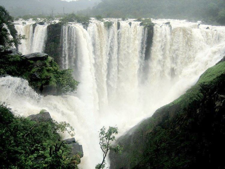
Jog Falls, Gerosoppa Falls or Joga Falls (ಜೋಗ ಜಲಪಾತ) is the highest plunge waterfall in India located near Sagara taluk, Shimoga district in the state of Karnataka. It is a segmented waterfall which, depending on rain and season, becomes a plunge waterfall. The falls are a major tourist attraction and is ranked 13th in the world by the waterfall database. They are also known as the Gersoppa Falls or Jogada Gundi.
Contents
- Jog falls karnataka
- Jog falls shimoga karnataka
- Description
- Etymology
- Significance
- Change in flow
- Power
- Transport connectivity
- References
The falls are located on the Uttara Kannada and Sagara border.
Jog falls shimoga karnataka
Description
Jog Falls is created by the Sharavathi River dropping 253 m (830 ft), making it the second-highest plunge waterfall in India after the Nohkalikai Falls with a drop of 335 m (1100 ft) in Meghalaya.
Sharavathi, a river which rises at Ambutirtha, next to Nonabur, in the Thirthahalli taluk and takes the northwesterly course by Fatte petta, receives the Haridravati on the right below Pattaguppe and the Yenne Hole on the left above Barangi. On arriving at the frontier it bends to the west, precipitates itself down the Falls of Gersoppa, and passes that village (properly Geru-Sappe), which is some 29 kilometres (18 mi) distant, discharging into the sea at Honnavar in North Kanara.
The Sharavati, flowing over a very rocky bed about 250 yards (230 m) wide, here reaches a tremendous chasm, 290 m (960 ft) deep, and the water comes down in four distinct falls. The Raja Fall pours in one unbroken column sheer to the depth of 830 ft (250 m). Halfway down it is encountered by the Roarer, another fall, which precipitates itself into a vast cup and then rushes violently downwards at an angle of forty-five degrees to meet the Raja. A third fall, the Rocket, shoots downwards in a series of jets; while the fourth, the Rani, moves quietly over the mountain side in a sheet of foam. The Tourism Department has built steps from the viewpoint to the bottom of the hill where the waterfall can be seen at the opposite side. There are approximately 1400 steps built to reach the bottom of the hill.
A Rock climber: Jyothi Raj has scaled the jog falls.
Etymology
Joga is a Kannada word meaning falls. Many Kannada speakers near Sahyadri Mountains such as in Yellapura region still use the word Joga to mean falls. The word Joga may be related to or a derivative of Kannada word javugu which means marsh (wet).
Significance
Associated with the waterfall is the nearby Linganmakki Dam across river Sharavathi. The power station has been operational since 1948 and is of 120 MW capacity, one of the largest hydroelectric stations in India at that time and a small source of electric power for Karnataka now. The power station was previously named Krishna Rajendra hydro-electric project, after the King of Mysore at that time. The name was later changed to Mahatma Gandhi Hydro-electric Project. It was served by Hirebhaskara dam until 1960. After 1960, due to the ideas of Sir M. Visvesvarayya, Linganmakki Dam has been used for power generation. For more information check the Jogfalls official website:
Change in flow
Before the onset of monsoon season, when there is not much water in the Linganmakki dam, the Jog Falls are a pair of thin streams of water trickling down the cliff, as the water collected in the dam is exclusively for generation of electricity; during monsoons local rain water is the source of water to the falls.
Power
Jog falls is used for hydroelectricity and can generate 6.7 MW of power.