
Official name Linganamakki Reservoir Creates Linganamakki Reservoir Catchment area 1991.71 km² Elevation 554 m Create Sharavati | Impounds Sharavathi River Total capacity 151.75 Tmcft Height 59 m Length 2,400 m Construction began 1964 | |
 | ||
Similar Jog Falls, Kodachadri, Supa Dam, Kodasalli Dam, Almatti Dam | ||
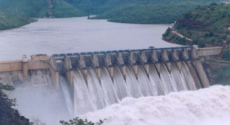
The Linganamakki dam(Kannada: ಲಿಂಗನಮಕ್ಕಿ ಅಣೆಕಟ್ಟು) was constructed by the Karnataka State Government in 1964. Located in the Sagara taluk, the dam has a length of 2.4 km, stretching across the Sharavathi river. It is located about 6 km from Jog Falls.
Map of Linganamakki dam, Karnataka 577421
The dam was designed to impound 4368 million cubic meter of water in an area of around 300 km², submerging 50.62 km² of wetland and 7 km² of dry land, with the remaining being forest land and wasteland .
The dam's height is 1,819 feet (554 m) above sea level. It receives water mainly from rainfall and also from the Chakra and Savahaklu reservoirs, which are linked to Linganamakki through a canal. The water from the Linganamakki dam flows to Talakalale Balancing Reservoir through a trapezoidal canal with a discharge capacity of 175.56 m³/s. The length of this channel is about 4318.40 m with a submersion of 7.77 km². It has a catchment area of about 46.60 km².
Behind the dam is a large reservoir. The discharge from the dam can be quite heavy. When the dam's sluice gates are closed upstream from Jog Falls, it is possible to walk down into the fall's ravine.
The power house has a power generation capacity of 55 MW, from two generating units. They are driven by vertical axis Kaplan turbines. The power house is on the left side of the dam.