Sneha Girap (Editor)

Jhalda

Updated on
Edit
Like
Comment
Share on FacebookTweet on TwitterShare on LinkedInShare on Reddit
Country
  
India

University
  
Achhruram Memorial College

Languages spoken
  
Bengali, English

State
  
West Bengal

District
  
Purulia


Jhalda is a city and a municipality in Purulia District in the Indian state of West Bengal.

Contents

Map of Jhalda

Demographics

As of 2010 India census, Jhalda had a population of 27,872. Males constitute 52% of the population and females 48%. Jhalda has an average literacy rate of 64%, higher than the national average of 59.5%: male literacy is 73%, and female literacy is 53%. In Jhalda, 14% of the population is under 6 years of age.

Education

There are schools like Satyabhama, Girls High School, Hindi High School and Jhlada High School.

Transport

It is on the Gomoh-Muri line.

Geography

Jhalda Beautiful Landscapes of Jhalda

Jhalda is located at 23.37°N 85.97°E? / 23.37; 85.97. It has an average elevation of 293 m (961 ft).

Jhalda Beautiful Landscapes of Jhalda

Jhalda has been declared as a Sub-Division in the year 2009 by the Chief Minister of W.B, Mr. Buddhadeb Bhattacharya. Jhalda has got two Blocks, Jhalda - I Development Block and Jhalda - II Development Block. Jhalda - I Development Block is situated at Mosina, Near Jhalda and Jhalda II Development Block is situated at Kotshila.

Maps of Jhalda I, and Jhalda II Development Block

Tourism

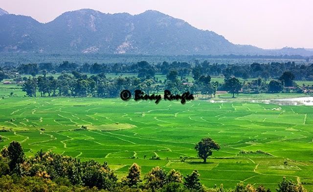
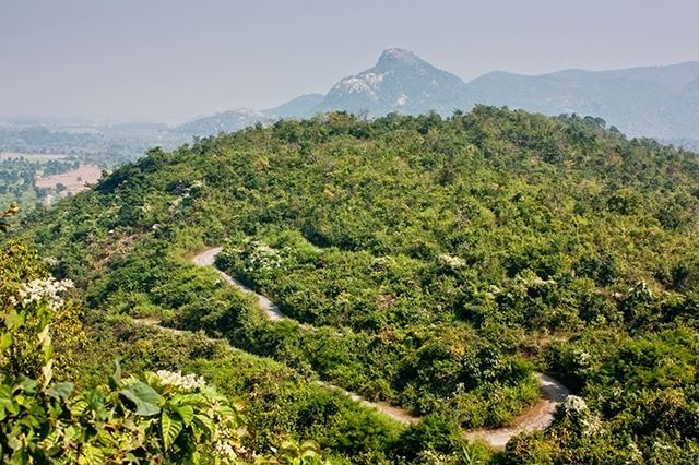
It is a small town surrounded by small hillocks. The main hills of the area are Shikra, Bansa, Kopla, Silphor, etc. The places of interest of the area are Norahara, Murguma, Kanrior, etc. Jhalda is adjacent to the state of Jharkhand (9 km from Muri (Jharkhand)). Jhalda Station is the railway station in the region. The village of Kotogara is on the other side of the mountains at Jhalda. Kotogara village is in Jharkhand

References

Jhalda Wikipedia (,)http://2.bp.blogspot.com/-BlzJVQbCABw/U3GpmoqwxAI/AAAAAAAAKNQ/nyZbGtJzVhQ/s1600/IMG_6534.jpg(,)http://4.bp.blogspot.com/-6MukhqO-ksA/U3GpHM7zDKI/AAAAAAAAKMo/2-0to7JE29o/s1600/IMG_4156.jpg(,)https://c2.staticflickr.com/6/5001/5265683222_444ae353a1_b.jpg(,)https://lh6.googleusercontent.com/-lKF-owvdWGU/VOMYg_xbyCI/AAAAAAAAABU/Y62luYLAwSg/w1153-h1154/2015-01-25%252B11.15.22.jpg(,)https://c2.staticflickr.com/6/5161/5265070579_55a4ef3347_b.jpg(,)http://ns4.cpanel.hu/~egzota9/tarolo/conifertreasury/2011/006%2520Malik/Pinus%2520leucodermis%2520%27Olymp%27%2520Halada%2520DSCN5782.JPG(,)http://www.files.conifertreasury.org/2011/029Halda/Picea%2520abies%2520%27Sonnenberg%27%2520Kalous%2520DSCN3414.JPG(,)http://ns4.cpanel.hu/~egzota9/tarolo/conifertreasury/2011/006%2520Malik/Pinus%2520leucodermis%2520%27Arachne%2520%2523%252032%27%2520DSCN5773.JPG(,)https://farm6.staticflickr.com/5290/5246000103_542aced9d7.jpg(,)http://mw2.google.com/mw-panoramio/photos/medium/42738611.jpg(,)http://mw2.google.com/mw-panoramio/photos/medium/70794942.jpg(,)http://mw2.google.com/mw-panoramio/photos/medium/11513121.jpg(,)http://mw2.google.com/mw-panoramio/photos/medium/49351544.jpg(,)http://i1.ytimg.com/vi/UirUQPFheG8/0.jpg(,)http://farm7.staticflickr.com/6149/5939943700_8c58b9574b.jpg(,)https://c2.staticflickr.com/6/5188/5563217671_c8609b3389_b.jpg(,)http://www.ideasforindia.in/Images/ArticleImg/Animesh-IAP-Fig%25202.png(,)http://media-cdn.tripadvisor.com/media/photo-s/04/58/92/e0/getlstd-property-photo.jpg(,)http://mw2.google.com/mw-panoramio/photos/medium/12971076.jpg(,)http://i.ytimg.com/vi/UirUQPFheG8/0.jpg(,)http://im1.indiarailinfo.com/634056/0/jhalidaa.jpg(,)http://mw2.google.com/mw-panoramio/photos/medium/45831519.jpg(,)http://i.ytimg.com/vi/K-ledq-08N8/hqdefault.jpg(,)http://im1.indiarailinfo.com/NEXT/812394/0/tho.jpg(,)http://upload.wikimedia.org/wikipedia/commons/a/a1/Purulia_Ayodhaya_Hills.jpg(,)http://www.mapsofindia.com/maps/westbengal/tehsil/puruliya-tehsil-map.jpg(,)http://www.mybudgettrip.com/west-bengal/purulia-banner.jpg