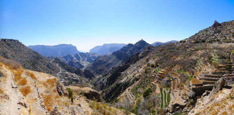
Mountains Jebel Shams | ||
 | ||
Similar Jebel Shams, Hajjar Mountains, Wahiba Sands, Bahla Fort, Nakhal Fort | ||
The Jebel Akhdar, Jabal Akhdar or Al Jabal Al Akhdar (Arabic: الجبل الأخضر meaning "the Green Mountain"), is part of the Al Hajar Mountains range in Ad Dakhiliyah Governorate of Oman. It extends about 300 km (186 mi) northwest to southeast, between 50–100 km (31–62 mi) inland from the Gulf of Oman coast, and is one of Oman’s most spectacular areas. The highest point, Jebel Shams (Mountain of the Sun), is around 3,000 metres (around 9,800 feet) high.
Map of Jebel Akhdar, Oman
This mostly limestone mountain is the highest point in Oman and the whole of eastern Arabia. Jebel Akhdar forms the central section of the Al Hajar Mountains range, and is located around 150 km (93 mi) from Muscat. The range is mostly desert, but at higher altitudes receives around 300 mm (12 in) of precipitation annually — moist enough to allow the growth of shrubs and trees and support agriculture. It is this that gives the mountains their "green" name. Cool summers provide the visitor with fresh air surrounded by breathtaking views of the stony mountainsides.
An old stronghold on the inland side of the mountain is Birkat al-Mawz, or Pool of the Plantains, with a layout similar to the nearby Jabrin palace. "Poised across the yawning mouth of a great pass into the mountains, Birkat al-Mawz was one of the fortresses of the Bani Riyam tribe which controlled the mountain heartland. Collapsing into ruin until recently, the mud-brick fortress and its painted ceilings are now well on the way to restoration."
The area is about a 45-minute drive from Nizwa and is famous for its traditional rose water extraction and agricultural products including pomegranates, walnuts, apricots, black grapes and peaches. It is also the site of honey bee breeding for much of Oman. Agricultural production is improved by the use of Aflaj irrigation channels and their associated terraces system devised by the local farmers, who have lived on this mountain for hundreds of years. The Jebel is mostly inhabited by the ancient Arab tribe Bani Riyam (al Riyamy). Most descendants of the tribe are now in the four nearby villages, including Nizwa, Izki and Ibra.
Between 1954 and 1959, the area became a site of the Jebel Akhdar War, a conflict between Omani forces loyal to the sultan of Oman (aided by British soldiers, including the Special Air Service) and Saudi Arabian-backed rebel forces of the inland Imamate of Oman.
In August 2011, Sultan Qaboos designated Jebel Akhdar a nature reserve in a bid to conserve its unique yet fragile biodiversity. A decree issued by Sultan Qaboos established the ‘Jebel Akhdar Sanctuary for Natural Sceneries.’ The Minister of Environment and Climate Affairs has authority to draft guidelines regulating access and developmental activity within the reserve.
Since 2011, the mountain has featured as the principal climb in the Tour of Oman road bicycle race. In the area, several important rock art sites, with figures dating back to 6000 years ago, have been discovered and studied.
