
Prominence 2,818 m | Elevation 3,028 m Parent range Hajjar Mountains | |
 | ||
Isolation 523 kilometres (325 mi) Listing Country high pointUltra Translation Mountain of Sun (Arabic) Easiest route (to South Summit) W4 route published by Ministry or Tourism, Oman (Grade 2 / 3) at Trekking Route 3 Similar Jebel Hafeet, Jabal Jais, Jabal Yibir, Dschabal Mischt | ||
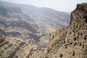
2016 jebel shams oman
Jebel Shams Arabic: جبل شمس, (mountain of sun) is a mountain located in northeastern Oman north of Al Hamra town. It is the highest mountain of the country and part of Al Hajar Mountains range. It is a popular sightseeing area located 240 km (149 mi) from Muscat. In the summer, temperature is around 20 °C (68 °F) and in the winter it drops to less than 0 °C (32 °F).
Contents
- 2016 jebel shams oman
- Map of Jebel Shams Jabal Shams Oman
- Jebel shams oman
- North Summit
- South Summit
- References
Map of Jebel Shams, Jabal Shams, Oman
Jebel shams oman
North Summit
The Jebel Shams true highest point is the North Summit, which is occupied by a military base and is a restricted area. The Ministry of Tourism, Sultanate of Oman, states the North Summit to be 3009 m (9872 ft) high.
South Summit
Jebel Shams has a second summit, the South Summit, which is publicly accessible for Trekking via the W4 Trail, marked by the Oman Ministry or Tourism, as published in Trekking Route 3. The elevation of the second south summit is 2997 m (9832 ft).