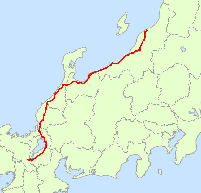
Puneet Varma (Editor)

Japan National Route 8

Updated on
Edit
Like
Comment
Share on FacebookTweet on TwitterShare on LinkedInShare on Reddit
Length
  
574.1 km

Japan National Route 8

Highway system
  
National highways of Japan

Major cities
  
Kanazawa, Nagaoka, Fukui, Toyama, Joetsu, Tsuruga, Kashiwazaki, Maibara, Otsu, Ritto

National Route 8 is an important highway in the Hokuriku and Kansai regions. It connects the prefectural capitals of Niigata, Toyama, Kanazawa (Ishikawa Prefecture), Fukui, Otsu (Shiga Prefecture), and Kyoto.

Contents

Map of Japan, %E5%9B%BD%E9%81%938%E5%8F%B7%E7%B7%9A

Route Data

  • Length: 574.1 km (356.7 mi)
  • Origin: Chuo-ku, Niigata (originates at junction with Routes 7, 17, 49, 113 and 116)
  • Terminus: Shimogyo-ku, Kyoto (ends at Junction with Routes 9, 24 and 367)
  • Major cities: Sanjo, Nagaoka, Kashiwazaki, Joetsu, Itoigawa, Toyama, Takaoka, Kanazawa, Hakusan, Komatsu, Fukui, Tsuruga, Maibara, Hikone, Otsu
  • Route 8 is the inspiration for the popular / Hachiban Ramen chain of noodle shops popular in the Hokuriku region.

    History

  • 1952-12-04 - First Class National Highway 8 (from Niigata to Kyoto)
  • 1965-04-01 - General National Highway 8 (from Niigata to Kyoto)
  • Intersecting routes

  • in Niigata Prefecture
  • Routes 7, 17, 18, 49, 113, 116, 148, 252, 253, 292, 350, 351, 352, 353, 403 and 460
  • in Toyama Prefecture
  • Routes 41, 156, 160, 415, 470, 471 and 472
  • in Ishikawa Prefecture
  • Routes 157, 159, 305, 360, 364 and 416
  • in Fukui Prefecture
  • Routes 27, 158, 161, 305, 365, 416, 417 and 476
  • in Shiga Prefecture
  • Routes 1, 21, 161, 303, 305, 306, 365, 421, 422 and 477
  • in Kyoto Prefecture
  • Routes 9, 24 and 367
  • References

    Japan National Route 8 Wikipedia