
Thickness around 2000 m | Length greater than 65 km. | |
 | ||
Area 110 000 km (whole catchment) Terminus Ocean (was floating now grounded) Similar Helheim Glacier, Petermann Glacier, Antarctic ice sheet, Northeast Greenland National, Hotel Arctic | ||
Daaitv daai headlines 20101028 jakobshavn glacier in retreat
Jakobshavn Glacier, also known as Sermeq Kujalleq (in Greenlandic) and the Jakobshavn Isbræ (in Danish), is a large outlet glacier in West Greenland. It is located near the Greenlandic town of Ilulissat (Danish: Jakobshavn) and ends at the sea in the Ilulissat Icefjord.
Contents
- Daaitv daai headlines 20101028 jakobshavn glacier in retreat
- Map of Jakobshavn Glacier Greenland
- Name
- Acceleration and retreat
- Chasing Ice
- References
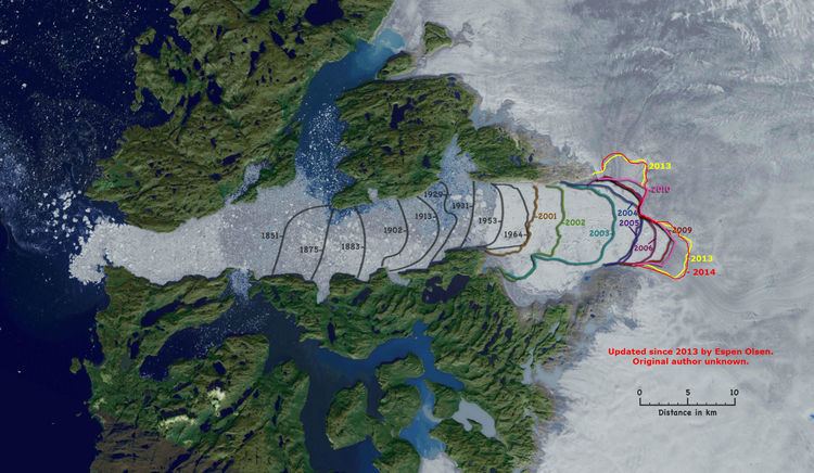
Map of Jakobshavn Glacier, Greenland
Jakobshavn Glacier drains 6.5% of the Greenland ice sheet and produces around 10% of all Greenland icebergs. Some 35 billion tonnes of icebergs calve off and pass out of the fjord every year. Icebergs breaking from the glacier are often so large (up to a kilometer in height) that they are too tall to float down the fjord and lie stuck on the bottom of its shallower areas, sometimes for years, until they are broken up by the force of the glacier and icebergs further up the fjord. Studied for over 250 years, Jakobshavn Glacier has helped develop our understanding of climate change and icecap glaciology.
Ilulissat Icefjord (Greenlandic: Ilulissat Kangerlua) was declared a UNESCO World Heritage Site in 2004.
Name
Jakobshavn has been a name used for this glacier in scientific literature since 1853 when Danish geologist Hinrich Johannes Rink referred to it as Jakobshavn Isstrøm (Danish for Jakobshavn Ice Stream). It is sometimes referred to in the international scientific literature (by glaciologists) as Jakobshavn Isbræ glacier. Isbræ is Danish for glacier. It is also commonly known by the anglicised version, Jakobshavn Glacier.
The local name for this glacier is Sermeq Kujalleq, where "sermeq "is Greenlandic for 'glacier' and "kujalleq" means 'southern'. It lies south of the town Ilulissat (formerly Jakobshavn). UNESCO's World Heritage Site website uses this name, in connection with mention of the Ilulissat Icefjord world heritage site, which includes the downstream end of the glacier.
There is evidence that people have inhabited the area around the glacier for up to 4000 years. The recently abandoned settlement of Sermermiut (which means 'place of the glacier people') lies just to the north of the glacier, much nearer than Ilulissat.
The glacier is sometimes referred to as Ilulissat Glacier. This form simply replaces Jakobshavn with Ilulissat because of the change in the name of the town.
Acceleration and retreat
Jakobshavn is one of the fastest moving glaciers, flowing at its terminus at speeds that used to be around 20 metres (66 ft) per day but are currently over 45 metres (150 ft) per day when averaged annually, with summer speeds even higher. The speed of Jakobshavn Glacier varied between 5,700 and 12,600 metres (18,700 and 41,300 ft) per year between 1992 and 2003. The ice stream's speed-up and near-doubling of ice flow from land into the ocean has increased the rate of sea level rise by about 0.06 millimetres (0.0024 in) per year, or roughly 4 percent of the 20th century rate of sea level rise. Jakobshavn Isbrae, retreated 30 km (19 mi) from 1850–1964, followed by a stationary front for 35 years. Jakobshavn has the highest mass flux of any glacier draining the Greenland Ice Sheet. The glacier terminus region also had a consistent velocity of 20 metres (66 ft) per day (maximum of 26 metres (85 ft) per day in the glacier center), from season to season and year to year, the glacier seemed to be in balance from 1955-1985. After 1997 the glacier began to accelerate and thin rapidly, reaching an average velocity of 34 metres (112 ft) per day in the terminus region. It also thinned at a rate of up to 15 metres (49 ft) per year and retreated 5 km (3.1 mi) in six years. Jakobshavn has afterwards slowed to near its pre-1997 speed, with the terminus retreat still occurring. On Jakobshavn the acceleration began at the calving front and spread up-glacier 20 km (12 mi) in 1997 and up to 55 km (34 mi) inland by 2003. The position of this calving front, or terminus, fluctuated by 2.5 km (1.6 mi) around its annual mean position between 1950 and 1996. The first mechanism for explaining the change in velocity is the "Zwally effect" and is not the main mechanism, this relies on meltwater reaching the glacier base and reducing the friction through a higher basal water pressure. A moulin is the conduit for the additional meltwater to reach the glacier base. This idea, proposed by Jay Zwally, was observed to be the cause of a brief seasonal acceleration of up to 20% on the Jakobshavns Glacier in 1998 and 1999 at Swiss Camp. The acceleration lasted 2–3 months and was less than 10% in 1996 and 1997 for example. They offered a conclusion that the "coupling between surface melting and ice-sheet flow provides a mechanism for rapid, large-scale, dynamic responses of ice sheets to climate warming". The acceleration of the three glaciers had not occurred at the time of this study and they were not concluding or implying that the meltwater increase was the cause of the aforementioned acceleration. Examination of recent rapid supra-glacial lake drainage documented short term velocity changes due to such events, but they had little significance to the annual flow of the large outlet glaciers.
The second mechanism is a "Jakobshavn effect", coined by Terry Hughes, where a small imbalance of forces caused by some perturbation can cause a substantial non-linear response. In this case an imbalance of forces at the calving front propagates up-glacier. Thinning causes the glacier to be more buoyant, even becoming afloat at the calving front, and is responsive to tidal changes. The reduced friction due to greater buoyancy allows for an increase in velocity. The reduced resistive force at the calving front is then propagated up glacier via longitudinal extension in what R. Thomas calls a backforce reduction.
This mechanism is supported by the data indicating no significant seasonal velocity changes at the calving front and the acceleration propagating upglacier from the calving front. The cause of the thinning could be a combination of increased surface ablation and basal ablation as one report presents data that show a sudden increase in subsurface ocean temperature in 1997 along the entire west coast of Greenland, and suggests that the changes in Jakobshavn Glacier are due to the arrival of relatively warm water originating from the Irminger Sea near Iceland.
In 2012 a significant acceleration of Jakobshavn was observed, with summer speeds up to 4 times its speed in the 1990s, and average annual speeds of 3 times its 1990s speed. Movement reached more than 17,000 metres per year.
Recent large calving events where the glacier produces icebergs have also been found to trigger earthquakes due to the icebergs scraping the bottom of the fjord. A recent large calving of approximately 7 km² took place on February 15, 2015. On August 16, 2015 a calving was identified via satellite images as the largest ever recorded at Jakobshavn, with an area of 12.5 km².
Evidence also exists for a deep subglacial trench beneath the glacial outlet, identified through seismic reflection methods. There are theories that Greenland consists of three large islands under the ice sheet, separated at the coast by three narrow straits, one of them Jakobshavn Glacier.
Chasing Ice
In the 2012 documentary entitled Chasing Ice by cinematographer Jeff Orlowski, nature photographer James Balog and his Extreme Ice Survey (EIS) team, there is a 75-minute segment showing the Jakobshavn Glacier calving. Two EIS videographers waited several weeks in a small tent overlooking the glacier, and were finally able to witness 7.4 cubic kilometres (1.8 cu mi) of ice crashing off the glacier. It was the longest calving ever captured on film. "The calving of a massive glacier believed to have produced the ice that sank the Titanic is like watching a city break apart."