
Elevation 1,160 m Parent range Blue Ridge Mountains | Prominence 97 m | |
 | ||
Similar Wolfpen Ridge, Brasstown Bald, Blood Mountain | ||
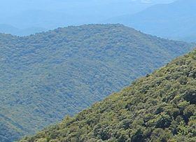
Jacks Knob is a mountain located on the border of Towns County and Union County, Georgia, with a peak elevation of 3,813 feet. The Appalachian Trail crosses the southern flank of the mountain and Jacks Knob Trail ends here at an intersection with the Appalachian Trail. Jacks Knob is in the Mark Trail Wilderness of the Chattahoochee National Forest.
Map of Jacks Knob, Georgia 30546, USA
The source of the Chattahoochee River is located in Jacks Gap at the southeastern foot of Jacks Knob, in the very southeastern corner of Union County.
References
Jacks Knob Wikipedia(Text) CC BY-SA