Settlements 336 – Villages 329 | Municipalities 5 and 1 city – Cities and towns 7 Area 2,769 km² | |
 | ||
Region | ||
The Jablanica District (Serbian: Јабланички округ / Jablanički okrug, [jâblaːnitʃkiː ôkruːɡ]) is one of nine administrative districts of Southern and Eastern Serbia. It expands in the south-eastern parts of Serbia. According to the 2011 census results, it has a population of 215,463 inhabitants. The administrative center of the district is the city of Leskovac.
Contents
- Map of Jablanica District Serbia
- Municipalities
- Demographics
- Ethnic groups
- History and culture
- Economy
- References
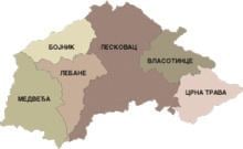
Map of Jablanica District, Serbia
Municipalities
The district encompasses the municipalities of:
Demographics
According to the 2011 census results, the Jablanica Distract has a total population of 216,304 inhabitants.
Ethnic groups
Ethnic composition of the Jablanica District:
History and culture
Famous cultural-historic monuments in this District are: the Roman necropolis in Mala Kopasnica originating from 2nd century AD, a late Roman-early Byzantine (6th century AD) town of Caričin Grad or Iustiniana Prima, the Jasunjski Monasteries dedicated to the Virgin of Transfiguration and St. John the Baptist, built in 1499 as the endowment of monastery sister Ksenija, as well as the church of St. John the Baptist from 16th century, being a true pearl among monuments.
Economy
Holders of economic development of the Jablanički District are: Pharmaceutical and chemical industry Zdravlje A.D., plastified tin-plate factory Pobeda, Tomako, meat producer Mesokombinat, "Letex" textile industry, "Nevena" cosmetics industry and others.
