
Settlements 48 Time zone CET (UTC+1) Local time Tuesday 6:11 PM | Elevation 234 m (768 ft) Area 308 km² | |
 | ||
Weather 13°C, Wind SW at 8 km/h, 64% Humidity | ||
Vlasotince (Serbian Cyrillic: Власотинце) is a town and municipality located in Jablanica District of the southern Serbia. The municipality has 29,669 inhabitants, while the town itself has a population of 15,830 (2011 census).
Contents
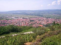
Map of Vlasotince, Serbia
History
According to Turkish records, the town existed in the 15th century as a Turkish administrative center. After the Turks were forced out of Serbia, locals started growing wine grapes as a kind of complementary business to their building activities. They made Vlasotince the number one wine region in the former Yugoslavia and furthermore the biggest wine exporter in the Balkans. The craftsmanship and building skills of workers and builders from this region were appreciated in the former Yugoslavia and its surrounding neighbours until the Yugoslav Wars.
Ethnic groups
Ethnic composition of the municipality:
Settlements
Aside from the town of Vlasotince, the municipality includes the following settlements: