
Length 28 km (17 mi) ENE/WSW | Width 18 km (11 mi) NNW/SSE Elevation 1,435 m | |
 | ||
Similar Bikku Bitti, Jebel Akhdar - Libya, Waw an Namus | ||
[[File:|thumb|]]
Contents
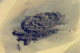
Map of Jabal Arkanu, Libya
Mount Arkanu or Jabal Arkanu (also Jebel Arkenu or Gebel Árchenu) is a mountain in Libya.
Geography
The mountain is located in the Libyan Desert in the Kufra District of Libya, about 300 km southeast of El Tag. and about 70 km west of Arkanu and the two Arkenu structures. Its height is 1,435 metres (4,708 ft), rising about 500 m above the surrounding Gilf Kebir plateau) and a valley-oasis. Mount Arkanu is 28 kilometres (17 mi) long and 18 kilometres (11 mi) wide.
Arkanu's existence had been known since 1892 through Arab sources, but the mountain was explored for the first time in 1923 by Ahmed Hassanein. The mountain consists of intrusive granite. The valley is 15 km long and oriented east-west. The vegetation consists of bushes, grass and some trees.
Arkanu is used as a pasture. Each year the Bedouins bring their herds in the valley, block the entrance (located at a height of 598 metres (1,962 ft)) with rocks, and return three months later to retrieve their cattle.