
Highest elevation 764 m (2,507 ft) Ethnic groups Japanese Elevation 764 m | Coastline 52 km (32.3 mi) Population 8,179 (October 2015) Area 91.06 km² Island group Izu Islands | |
 | ||
Points of interest Mount Mihara, Oshimaonsenmotomachihama Hot Spring, Miharayama Hot Spring, Izuoshimakazan Museum, Toritsu Oshima Park Zoo | ||
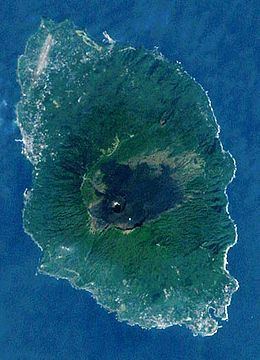
Izu Ōshima (伊豆大島, Izu-ōshima) is an inhabited volcanic island in the Izu archipelago in the Philippine Sea, approximately 120 kilometres (75 mi) southeast of Honshu, Japan, 22 km (14 mi) east of the Izu Peninsula and 36 km (22 mi) southwest of Bōsō Peninsula. As with the other islands in the Izu Island group, Miyake-jima forms part of the Fuji-Hakone-Izu National Park. Izu Ōshima, at 91.06 km² is the largest and closest of Tokyo's outlying islands, which also include the Ogasawara Islands.
Contents
- Map of Oshima Island Oshima Tokyo Japan
- Geography
- Climate
- Administration
- Access
- Popular fiction
- References
Map of Oshima Island, Oshima, Tokyo, Japan
Geography
The island is a stratovolcano with a basaltic composite cone, dating from the late Pleistocene period, between 10,000 and 15,000 years ago, rain from an ocean floor with a depth of between 300 and 400 meters, The island has a roughly circular coastline of approximately 52 kilometers in length. The highest elevation Mount Mihara (三原山, Mihara-san) is an active volcano with a height of 758 meters. The mountain has been recorded to have erupted numerous times throughout history, and is mentioned as far back as Nara period written records.
Major eruptions occurred in 1965 and 1986, each forcing the temporary evacuation of the inhabitants. The last recorded eruption was in 1990.
Climate
Izu Ōshima has a humid subtropical climate (Köppen climate classification Cfa) with warm summers and cool winters. Precipitation is abundant throughout the year, but is somewhat lower in winter than the rest of the year.
Administration
The island is administered by the Ōshima subprefecture of the Tokyo Metropolitan government. As of June 1, 2016, the population of the island was 2451. Ōshima Town (三宅村, Ōshima-machi) serves as the local government of the island.
Ōshima Town consists of the six traditional hamlets of Okada, Motomura, Senzu, Nomashi, Sashikiji and Habuminato, with Motomachi as the administrative center.
Access
Izu Ōshima is a popular site for tourists from both Tokyo and Shizuoka due to its close proximity to the mainland. There are a number of ferries which leave from Takeshiba Sanbashi Pier, near Hamamatsuchō, Tokyo. Ferries also leave from Atami in Shizuoka.
There are several flights per day from Ōshima Airport to Tokyo International Airport (Haneda), Hachijojima Airport in Hachijojima and Chōfu Airport in Chōfu (all four airports are in Tokyo).
Popular fiction
Mount Miharu and Izu Ōshima featured prominently in The Return of Godzilla, as the location in which the Japanese government entombed Godzilla. Mt. Mihara appeared again in the direct sequel, Godzilla vs. Biollante, in which Godzilla was released when the volcano erupted.
Mt. Mihara and Izu Ōshima were also featured in the book Ring and the movie Ring as pivotal locations for the story.
In the Pokémon franchise, Cinnabar Island is based on Izu Ōshima.